You are here: Home > Network List > TA - USArray Transportable Network (new EarthScope stations) Stations List
> Station M42A Sheffield, IL, USA > Earthquake Result Viewer
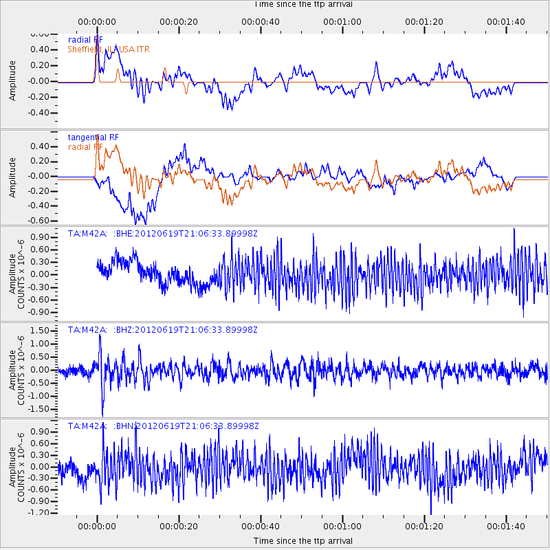
M42A Sheffield, IL, USA - Earthquake Result Viewer
*The percent match for this event was below the threshold and hence no stack was calculated.
| Earthquake location: |
Near Islands, Aleutian Islands |
| Earthquake latitude/longitude: |
53.4/171.7 |
| Earthquake time(UTC): |
2012/06/19 (171) 20:56:41 GMT |
| Earthquake Depth: |
12 km |
| Earthquake Magnitude: |
5.9 MB, 5.2 MS, 5.6 MW, 5.7 MW |
| Earthquake Catalog/Contributor: |
WHDF/NEIC |
|
| Network: |
TA USArray Transportable Network (new EarthScope stations) |
| Station: |
M42A Sheffield, IL, USA |
| Lat/Lon: |
41.45 N/89.76 W |
| Elevation: |
212 m |
|
| Distance: |
62.6 deg |
| Az: |
56.892 deg |
| Baz: |
318.084 deg |
| Ray Param: |
$rayparam |
*The percent match for this event was below the threshold and hence was not used in the summary stack. |
|
| Radial Match: |
48.09086 % |
| Radial Bump: |
400 |
| Transverse Match: |
36.48732 % |
| Transverse Bump: |
400 |
| SOD ConfigId: |
460165 |
| Insert Time: |
2013-02-11 23:18:09.169 +0000 |
| GWidth: |
2.5 |
| Max Bumps: |
400 |
| Tol: |
0.001 |
|
Signal To Noise
| Channel | StoN | STA | LTA |
| TA:M42A: :BHZ:20120619T21:06:33.89998Z | 4.0360885 | 6.2036287E-7 | 1.5370398E-7 |
| TA:M42A: :BHN:20120619T21:06:33.89998Z | 2.5628765 | 4.3268878E-7 | 1.6882936E-7 |
| TA:M42A: :BHE:20120619T21:06:33.89998Z | 1.4145142 | 3.4259287E-7 | 2.4219824E-7 |
| Arrivals |
| Ps | |
| PpPs | |
| PsPs/PpSs | |


