You are here: Home > Network List > G - GEOSCOPE Stations List
> Station SPB Sao Paulo, Brazil > Earthquake Result Viewer
SPB Sao Paulo, Brazil - Earthquake Result Viewer
| Earthquake location: |
Mexico-Guatemala Border Region |
| Earthquake latitude/longitude: |
15.4/-92.7 |
| Earthquake time(UTC): |
2001/01/19 (019) 01:12:52 GMT |
| Earthquake Depth: |
93 km |
| Earthquake Magnitude: |
5.4 MB, 5.6 MD |
| Earthquake Catalog/Contributor: |
WHDF/NEIC |
|
| Network: |
G GEOSCOPE |
| Station: |
SPB Sao Paulo, Brazil |
| Lat/Lon: |
23.59 S/47.43 W |
| Elevation: |
85 m |
|
| Distance: |
58.8 deg |
| Az: |
130.368 deg |
| Baz: |
306.77 deg |
| Ray Param: |
0.062319916 |
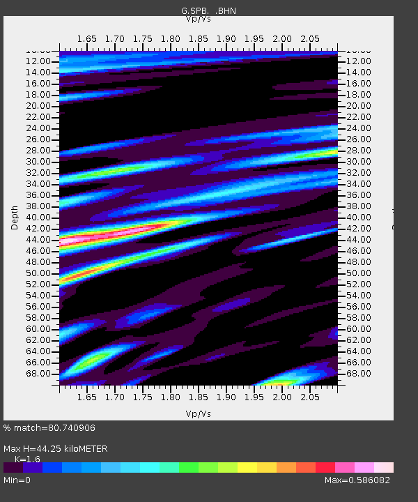
| Estimated Moho Depth: |
44.25 km |
| Estimated Crust Vp/Vs: |
1.60 |
| Assumed Crust Vp: |
6.419 km/s |
| Estimated Crust Vs: |
4.012 km/s |
| Estimated Crust Poisson's Ratio: |
0.18 |
|
| Radial Match: |
80.740906 % |
| Radial Bump: |
400 |
| Transverse Match: |
58.53888 % |
| Transverse Bump: |
400 |
| SOD ConfigId: |
3753 |
| Insert Time: |
2010-02-27 00:03:55.960 +0000 |
| GWidth: |
2.5 |
| Max Bumps: |
400 |
| Tol: |
0.001 |
|
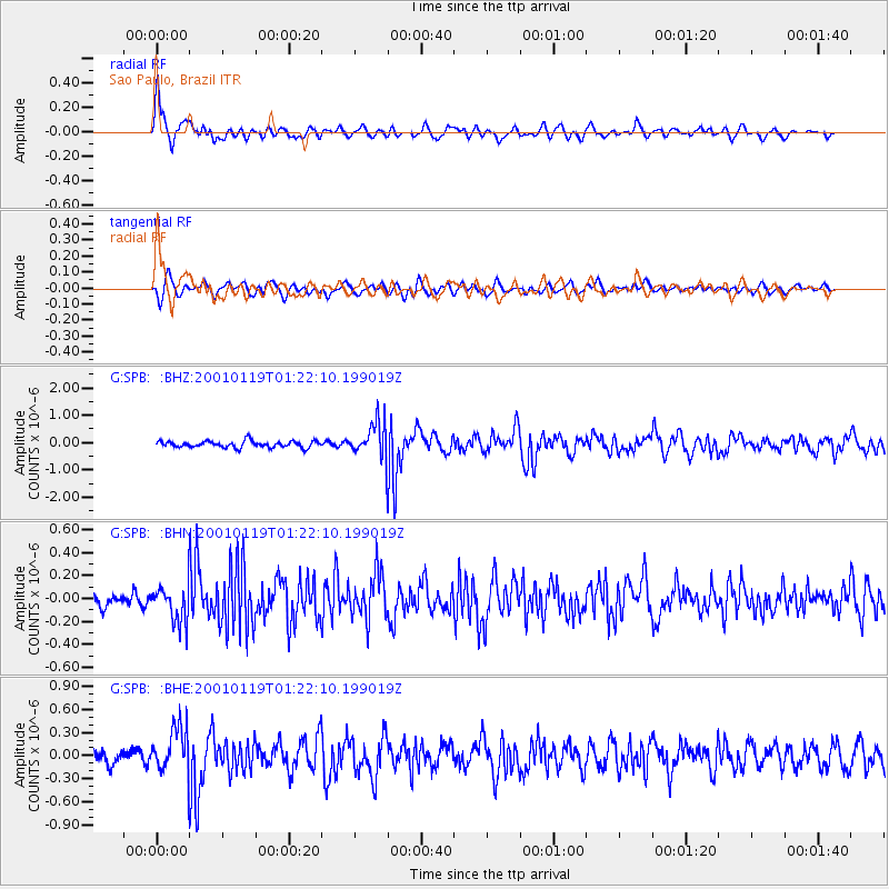
Signal To Noise
| Channel | StoN | STA | LTA |
| G:SPB: :BHN:20010119T01:22:10.199019Z | 2.069616 | 1.6177825E-7 | 7.816824E-8 |
| G:SPB: :BHE:20010119T01:22:10.199019Z | 2.8790522 | 2.9455816E-7 | 1.0231081E-7 |
| G:SPB: :BHZ:20010119T01:22:10.199019Z | 5.4688416 | 6.5110066E-7 | 1.1905641E-7 |
| Arrivals |
| Ps | 4.4 SECOND |
| PpPs | 17 SECOND |
| PsPs/PpSs | 21 SECOND |


