You are here: Home > Network List > XJ13 - CRAFTI Stations List
> Station PR31 Engaruka Boma > Earthquake Result Viewer
PR31 Engaruka Boma - Earthquake Result Viewer
| Earthquake location: |
Bay Of Bengal |
| Earthquake latitude/longitude: |
18.3/88.1 |
| Earthquake time(UTC): |
2014/05/21 (141) 16:21:54 GMT |
| Earthquake Depth: |
40 km |
| Earthquake Magnitude: |
6.0 MWB |
| Earthquake Catalog/Contributor: |
NEIC PDE/NEIC COMCAT |
|
| Network: |
XJ CRAFTI |
| Station: |
PR31 Engaruka Boma |
| Lat/Lon: |
2.92 S/36.05 E |
| Elevation: |
884 m |
|
| Distance: |
55.4 deg |
| Az: |
253.09 deg |
| Baz: |
65.557 deg |
| Ray Param: |
0.06474839 |
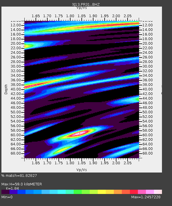
| Estimated Moho Depth: |
59.0 km |
| Estimated Crust Vp/Vs: |
1.84 |
| Assumed Crust Vp: |
6.601 km/s |
| Estimated Crust Vs: |
3.587 km/s |
| Estimated Crust Poisson's Ratio: |
0.29 |
|
| Radial Match: |
81.82827 % |
| Radial Bump: |
400 |
| Transverse Match: |
51.59232 % |
| Transverse Bump: |
400 |
| SOD ConfigId: |
3390531 |
| Insert Time: |
2019-04-11 23:56:07.778 +0000 |
| GWidth: |
2.5 |
| Max Bumps: |
400 |
| Tol: |
0.001 |
|

Signal To Noise
| Channel | StoN | STA | LTA |
| XJ:PR31: :BHZ:20140521T16:30:52.99998Z | 3.8394418 | 3.0049864E-7 | 7.826623E-8 |
| XJ:PR31: :BHN:20140521T16:30:52.99998Z | 2.0458775 | 1.8186448E-7 | 8.8893145E-8 |
| XJ:PR31: :BHE:20140521T16:30:52.99998Z | 1.5559489 | 1.6382857E-7 | 1.05291754E-7 |
| Arrivals |
| Ps | 7.9 SECOND |
| PpPs | 24 SECOND |
| PsPs/PpSs | 32 SECOND |


