You are here: Home > Network List > TA - USArray Transportable Network (new EarthScope stations) Stations List
> Station O45A Potomac, IL, USA > Earthquake Result Viewer
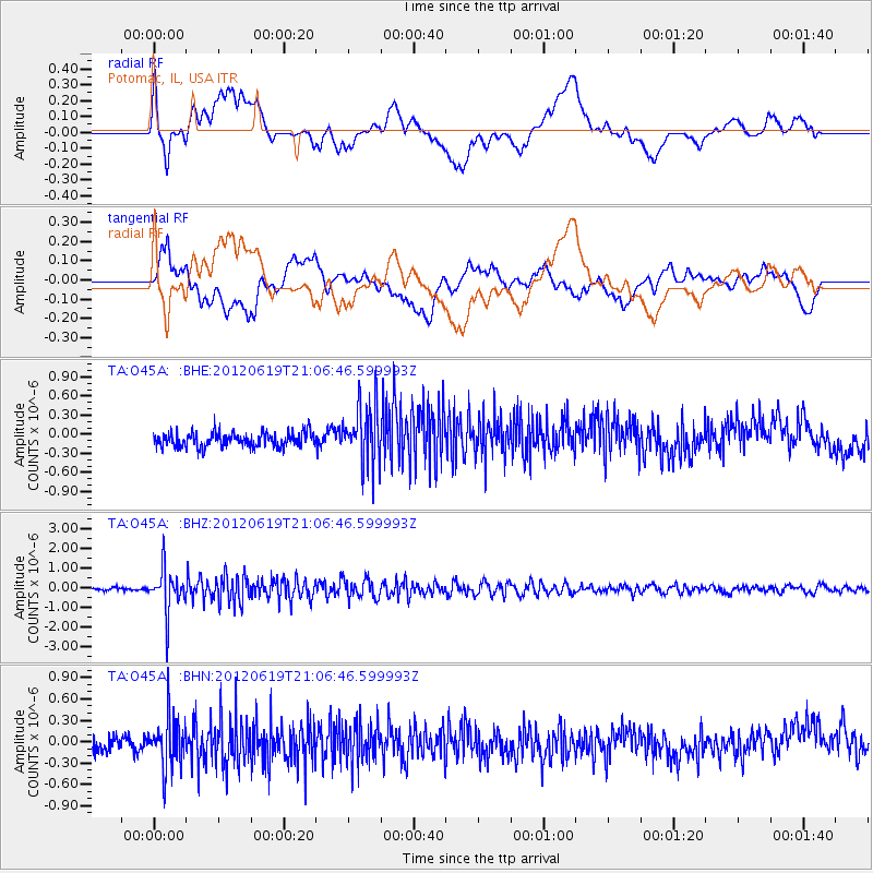
O45A Potomac, IL, USA - Earthquake Result Viewer
*The percent match for this event was below the threshold and hence no stack was calculated.
| Earthquake location: |
Near Islands, Aleutian Islands |
| Earthquake latitude/longitude: |
53.4/171.7 |
| Earthquake time(UTC): |
2012/06/19 (171) 20:56:41 GMT |
| Earthquake Depth: |
12 km |
| Earthquake Magnitude: |
5.9 MB, 5.2 MS, 5.6 MW, 5.7 MW |
| Earthquake Catalog/Contributor: |
WHDF/NEIC |
|
| Network: |
TA USArray Transportable Network (new EarthScope stations) |
| Station: |
O45A Potomac, IL, USA |
| Lat/Lon: |
40.25 N/87.72 W |
| Elevation: |
208 m |
|
| Distance: |
64.5 deg |
| Az: |
56.487 deg |
| Baz: |
319.228 deg |
| Ray Param: |
$rayparam |
*The percent match for this event was below the threshold and hence was not used in the summary stack. |
|
| Radial Match: |
65.8922 % |
| Radial Bump: |
400 |
| Transverse Match: |
62.902542 % |
| Transverse Bump: |
400 |
| SOD ConfigId: |
460165 |
| Insert Time: |
2013-02-11 23:23:45.441 +0000 |
| GWidth: |
2.5 |
| Max Bumps: |
400 |
| Tol: |
0.001 |
|
Signal To Noise
| Channel | StoN | STA | LTA |
| TA:O45A: :BHZ:20120619T21:06:46.599993Z | 13.711831 | 1.1189288E-6 | 8.160317E-8 |
| TA:O45A: :BHN:20120619T21:06:46.599993Z | 3.246202 | 3.6255608E-7 | 1.11686234E-7 |
| TA:O45A: :BHE:20120619T21:06:46.599993Z | 4.1977677 | 4.7645082E-7 | 1.1350099E-7 |
| Arrivals |
| Ps | |
| PpPs | |
| PsPs/PpSs | |


