You are here: Home > Network List > YB13 - Continental Dynamics/Cent. Anatolian Tectonics:Surface to Mantle Dynamics During Stations List
> Station AT21 Asiklar,Nevsehir,Turkey > Earthquake Result Viewer
AT21 Asiklar,Nevsehir,Turkey - Earthquake Result Viewer
| Earthquake location: |
Bay Of Bengal |
| Earthquake latitude/longitude: |
18.3/88.1 |
| Earthquake time(UTC): |
2014/05/21 (141) 16:21:54 GMT |
| Earthquake Depth: |
40 km |
| Earthquake Magnitude: |
6.0 MWB |
| Earthquake Catalog/Contributor: |
NEIC PDE/NEIC COMCAT |
|
| Network: |
YB Continental Dynamics/Cent. Anatolian Tectonics:Surface to Mantle Dynamics During |
| Station: |
AT21 Asiklar,Nevsehir,Turkey |
| Lat/Lon: |
38.93 N/34.52 E |
| Elevation: |
1279 m |
|
| Distance: |
50.6 deg |
| Az: |
305.672 deg |
| Baz: |
98.219 deg |
| Ray Param: |
0.06787767 |
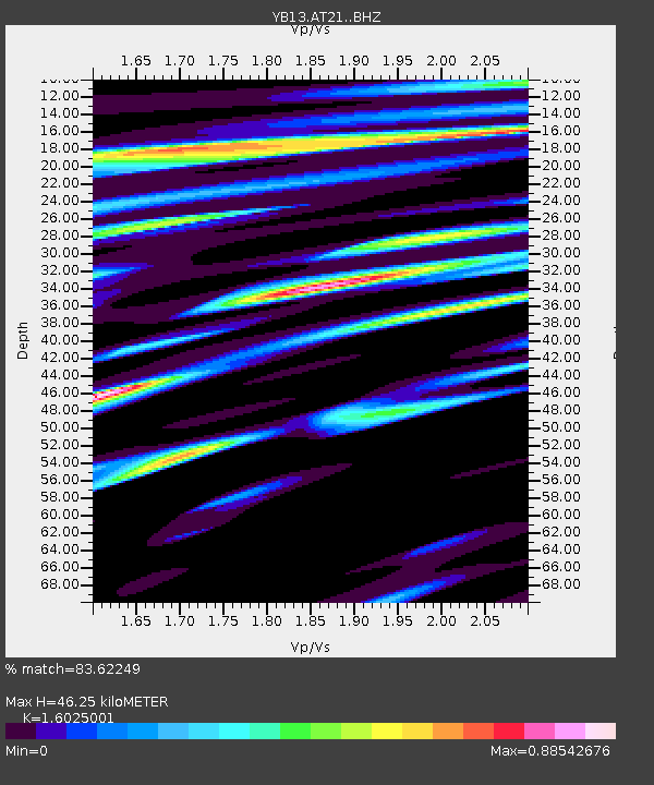
| Estimated Moho Depth: |
46.25 km |
| Estimated Crust Vp/Vs: |
1.60 |
| Assumed Crust Vp: |
6.35 km/s |
| Estimated Crust Vs: |
3.963 km/s |
| Estimated Crust Poisson's Ratio: |
0.18 |
|
| Radial Match: |
83.62249 % |
| Radial Bump: |
400 |
| Transverse Match: |
75.59295 % |
| Transverse Bump: |
400 |
| SOD ConfigId: |
3390531 |
| Insert Time: |
2019-04-11 23:56:25.651 +0000 |
| GWidth: |
2.5 |
| Max Bumps: |
400 |
| Tol: |
0.001 |
|

Signal To Noise
| Channel | StoN | STA | LTA |
| YB:AT21: :BHZ:20140521T16:30:17.720012Z | 8.690871 | 4.4810324E-7 | 5.156022E-8 |
| YB:AT21: :BHN:20140521T16:30:17.720012Z | 2.323076 | 1.3198125E-7 | 5.681314E-8 |
| YB:AT21: :BHE:20140521T16:30:17.720012Z | 4.395079 | 2.2923346E-7 | 5.2156846E-8 |
| Arrivals |
| Ps | 4.7 SECOND |
| PpPs | 18 SECOND |
| PsPs/PpSs | 22 SECOND |


