You are here: Home > Network List > TA - USArray Transportable Network (new EarthScope stations) Stations List
> Station 252A Lumpkin, GA, USA > Earthquake Result Viewer
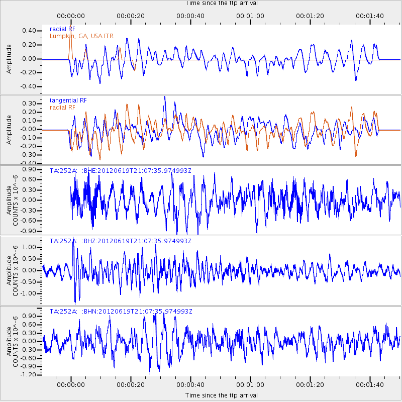
252A Lumpkin, GA, USA - Earthquake Result Viewer
*The percent match for this event was below the threshold and hence no stack was calculated.
| Earthquake location: |
Near Islands, Aleutian Islands |
| Earthquake latitude/longitude: |
53.4/171.7 |
| Earthquake time(UTC): |
2012/06/19 (171) 20:56:41 GMT |
| Earthquake Depth: |
12 km |
| Earthquake Magnitude: |
5.9 MB, 5.2 MS, 5.6 MW, 5.7 MW |
| Earthquake Catalog/Contributor: |
WHDF/NEIC |
|
| Network: |
TA USArray Transportable Network (new EarthScope stations) |
| Station: |
252A Lumpkin, GA, USA |
| Lat/Lon: |
32.00 N/84.74 W |
| Elevation: |
142 m |
|
| Distance: |
72.4 deg |
| Az: |
60.066 deg |
| Baz: |
322.307 deg |
| Ray Param: |
$rayparam |
*The percent match for this event was below the threshold and hence was not used in the summary stack. |
|
| Radial Match: |
41.159237 % |
| Radial Bump: |
400 |
| Transverse Match: |
46.047787 % |
| Transverse Bump: |
400 |
| SOD ConfigId: |
460165 |
| Insert Time: |
2013-02-11 23:30:24.619 +0000 |
| GWidth: |
2.5 |
| Max Bumps: |
400 |
| Tol: |
0.001 |
|
Signal To Noise
| Channel | StoN | STA | LTA |
| TA:252A: :BHZ:20120619T21:07:35.974993Z | 3.838483 | 6.3672195E-7 | 1.6587853E-7 |
| TA:252A: :BHN:20120619T21:07:35.974993Z | 1.3398508 | 3.2680956E-7 | 2.4391488E-7 |
| TA:252A: :BHE:20120619T21:07:35.974993Z | 1.2061 | 3.8472962E-7 | 3.1898648E-7 |
| Arrivals |
| Ps | |
| PpPs | |
| PsPs/PpSs | |


