You are here: Home > Network List > G - GEOSCOPE Stations List
> Station SPB Sao Paulo, Brazil > Earthquake Result Viewer
SPB Sao Paulo, Brazil - Earthquake Result Viewer
| Earthquake location: |
South Sandwich Islands Region |
| Earthquake latitude/longitude: |
-56.5/-27.5 |
| Earthquake time(UTC): |
2002/11/12 (316) 01:46:48 GMT |
| Earthquake Depth: |
120 km |
| Earthquake Magnitude: |
6.0 MB, 6.3 MW, 6.2 MW |
| Earthquake Catalog/Contributor: |
WHDF/NEIC |
|
| Network: |
G GEOSCOPE |
| Station: |
SPB Sao Paulo, Brazil |
| Lat/Lon: |
23.59 S/47.43 W |
| Elevation: |
85 m |
|
| Distance: |
36.0 deg |
| Az: |
327.91 deg |
| Baz: |
161.296 deg |
| Ray Param: |
0.07652024 |
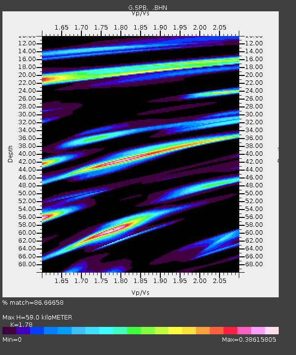
| Estimated Moho Depth: |
59.0 km |
| Estimated Crust Vp/Vs: |
1.78 |
| Assumed Crust Vp: |
6.419 km/s |
| Estimated Crust Vs: |
3.606 km/s |
| Estimated Crust Poisson's Ratio: |
0.27 |
|
| Radial Match: |
86.66658 % |
| Radial Bump: |
400 |
| Transverse Match: |
67.9393 % |
| Transverse Bump: |
400 |
| SOD ConfigId: |
4714 |
| Insert Time: |
2010-02-27 00:04:14.210 +0000 |
| GWidth: |
2.5 |
| Max Bumps: |
400 |
| Tol: |
0.001 |
|
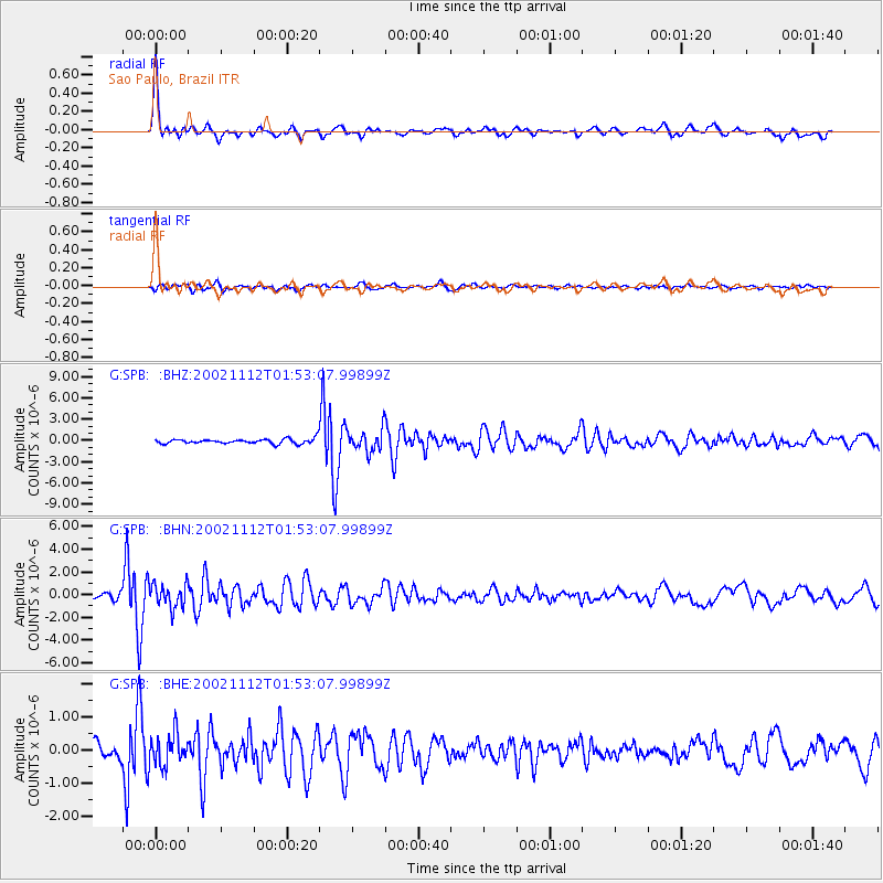
Signal To Noise
| Channel | StoN | STA | LTA |
| G:SPB: :BHN:20021112T01:53:07.99899Z | 4.158852 | 1.0226686E-6 | 2.4590165E-7 |
| G:SPB: :BHE:20021112T01:53:07.99899Z | 1.8825358 | 4.7930433E-7 | 2.546057E-7 |
| G:SPB: :BHZ:20021112T01:53:07.99899Z | 4.5458717 | 1.5557471E-6 | 3.4223297E-7 |
| Arrivals |
| Ps | 7.7 SECOND |
| PpPs | 24 SECOND |
| PsPs/PpSs | 31 SECOND |


