You are here: Home > Network List > UW - Pacific Northwest Regional Seismic Network Stations List
> Station LEBA Lebam, WA, USA > Earthquake Result Viewer
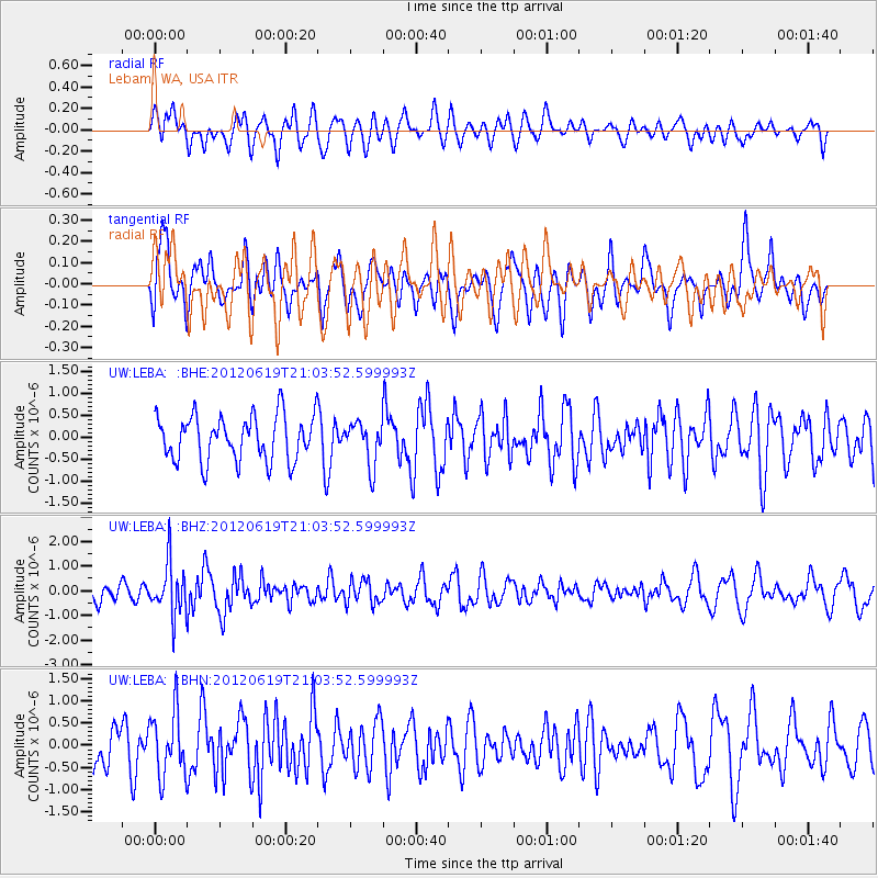
LEBA Lebam, WA, USA - Earthquake Result Viewer
*The percent match for this event was below the threshold and hence no stack was calculated.
| Earthquake location: |
Near Islands, Aleutian Islands |
| Earthquake latitude/longitude: |
53.4/171.7 |
| Earthquake time(UTC): |
2012/06/19 (171) 20:56:41 GMT |
| Earthquake Depth: |
12 km |
| Earthquake Magnitude: |
5.9 MB, 5.2 MS, 5.6 MW, 5.7 MW |
| Earthquake Catalog/Contributor: |
WHDF/NEIC |
|
| Network: |
UW Pacific Northwest Regional Seismic Network |
| Station: |
LEBA Lebam, WA, USA |
| Lat/Lon: |
46.55 N/123.56 W |
| Elevation: |
73 m |
|
| Distance: |
40.9 deg |
| Az: |
72.398 deg |
| Baz: |
304.116 deg |
| Ray Param: |
$rayparam |
*The percent match for this event was below the threshold and hence was not used in the summary stack. |
|
| Radial Match: |
52.5869 % |
| Radial Bump: |
400 |
| Transverse Match: |
62.75651 % |
| Transverse Bump: |
400 |
| SOD ConfigId: |
460165 |
| Insert Time: |
2013-02-11 23:37:06.877 +0000 |
| GWidth: |
2.5 |
| Max Bumps: |
400 |
| Tol: |
0.001 |
|
Signal To Noise
| Channel | StoN | STA | LTA |
| UW:LEBA: :BHZ:20120619T21:03:52.599993Z | 3.4393206 | 1.0510028E-6 | 3.0558442E-7 |
| UW:LEBA: :BHN:20120619T21:03:52.599993Z | 1.9775476 | 7.201383E-7 | 3.6415724E-7 |
| UW:LEBA: :BHE:20120619T21:03:52.599993Z | 0.94954574 | 4.881129E-7 | 5.1404885E-7 |
| Arrivals |
| Ps | |
| PpPs | |
| PsPs/PpSs | |


