You are here: Home > Network List > IC - New China Digital Seismograph Network Stations List
> Station LSA Tibet, China > Earthquake Result Viewer
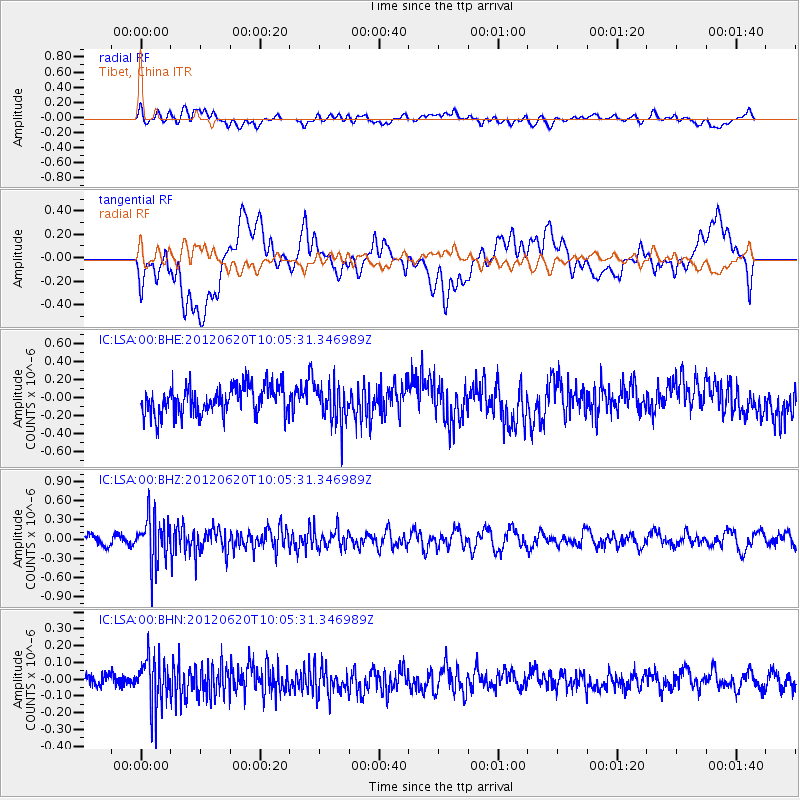
LSA Tibet, China - Earthquake Result Viewer
*The percent match for this event was below the threshold and hence no stack was calculated.
| Earthquake location: |
Southern Sumatra, Indonesia |
| Earthquake latitude/longitude: |
-4.9/103.2 |
| Earthquake time(UTC): |
2012/06/20 (172) 09:59:04 GMT |
| Earthquake Depth: |
70 km |
| Earthquake Magnitude: |
5.6 MB, 5.2 MW, 5.3 MW |
| Earthquake Catalog/Contributor: |
WHDF/NEIC |
|
| Network: |
IC New China Digital Seismograph Network |
| Station: |
LSA Tibet, China |
| Lat/Lon: |
29.70 N/91.13 E |
| Elevation: |
3660 m |
|
| Distance: |
36.3 deg |
| Az: |
342.12 deg |
| Baz: |
159.415 deg |
| Ray Param: |
$rayparam |
*The percent match for this event was below the threshold and hence was not used in the summary stack. |
|
| Radial Match: |
54.51654 % |
| Radial Bump: |
400 |
| Transverse Match: |
51.86347 % |
| Transverse Bump: |
400 |
| SOD ConfigId: |
460165 |
| Insert Time: |
2013-02-11 23:47:25.225 +0000 |
| GWidth: |
2.5 |
| Max Bumps: |
400 |
| Tol: |
0.001 |
|
Signal To Noise
| Channel | StoN | STA | LTA |
| IC:LSA:00:BHZ:20120620T10:05:31.346989Z | 3.7655356 | 3.5555277E-7 | 9.4422894E-8 |
| IC:LSA:00:BHN:20120620T10:05:31.346989Z | 3.989207 | 1.4163362E-7 | 3.5504204E-8 |
| IC:LSA:00:BHE:20120620T10:05:31.346989Z | 1.380708 | 2.2120436E-7 | 1.6021082E-7 |
| Arrivals |
| Ps | |
| PpPs | |
| PsPs/PpSs | |


