You are here: Home > Network List > TA - USArray Transportable Network (new EarthScope stations) Stations List
> Station TPFO Pinon Flats, CA, USA > Earthquake Result Viewer
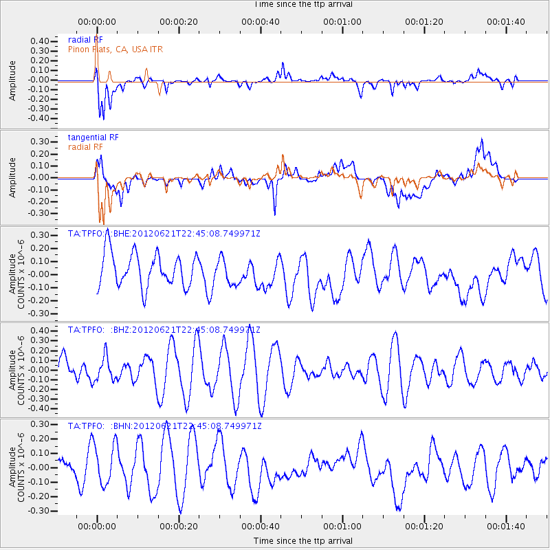
TPFO Pinon Flats, CA, USA - Earthquake Result Viewer
*The percent match for this event was below the threshold and hence no stack was calculated.
| Earthquake location: |
Fiji Islands Region |
| Earthquake latitude/longitude: |
-18.0/-178.2 |
| Earthquake time(UTC): |
2012/06/21 (173) 22:34:37 GMT |
| Earthquake Depth: |
543 km |
| Earthquake Magnitude: |
5.5 MW, 5.2 MB, 5.5 MW |
| Earthquake Catalog/Contributor: |
WHDF/NEIC |
|
| Network: |
TA USArray Transportable Network (new EarthScope stations) |
| Station: |
TPFO Pinon Flats, CA, USA |
| Lat/Lon: |
33.61 N/116.45 W |
| Elevation: |
1275 m |
|
| Distance: |
78.0 deg |
| Az: |
48.709 deg |
| Baz: |
238.978 deg |
| Ray Param: |
$rayparam |
*The percent match for this event was below the threshold and hence was not used in the summary stack. |
|
| Radial Match: |
66.00998 % |
| Radial Bump: |
400 |
| Transverse Match: |
43.81476 % |
| Transverse Bump: |
400 |
| SOD ConfigId: |
460165 |
| Insert Time: |
2013-02-12 00:06:53.473 +0000 |
| GWidth: |
2.5 |
| Max Bumps: |
400 |
| Tol: |
0.001 |
|
Signal To Noise
| Channel | StoN | STA | LTA |
| TA:TPFO: :BHZ:20120621T22:45:08.749971Z | 0.4644095 | 1.2263467E-7 | 2.640658E-7 |
| TA:TPFO: :BHN:20120621T22:45:08.749971Z | 2.336606 | 1.4818855E-7 | 6.342043E-8 |
| TA:TPFO: :BHE:20120621T22:45:08.749971Z | 0.7800554 | 9.901577E-8 | 1.2693428E-7 |
| Arrivals |
| Ps | |
| PpPs | |
| PsPs/PpSs | |


