You are here: Home > Network List > TA - USArray Transportable Network (new EarthScope stations) Stations List
> Station R11A Troy Canyon, Currant, NV, USA > Earthquake Result Viewer
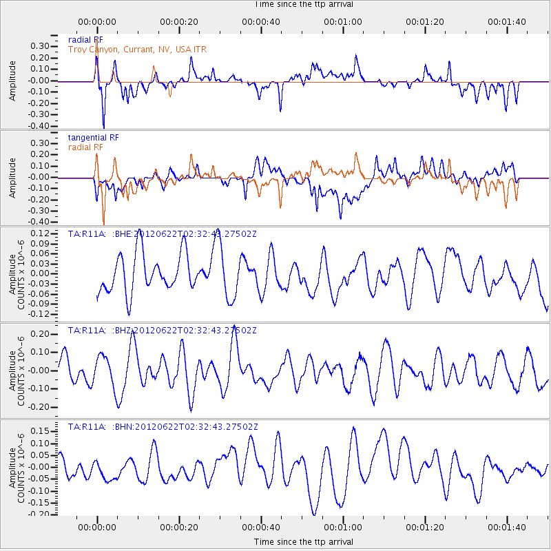
R11A Troy Canyon, Currant, NV, USA - Earthquake Result Viewer
*The percent match for this event was below the threshold and hence no stack was calculated.
| Earthquake location: |
South Of Kermadec Islands |
| Earthquake latitude/longitude: |
-32.9/-178.6 |
| Earthquake time(UTC): |
2012/06/22 (174) 02:20:06 GMT |
| Earthquake Depth: |
14 km |
| Earthquake Magnitude: |
5.5 MW, 5.4 MS, 5.3 MB, 5.7 MW |
| Earthquake Catalog/Contributor: |
WHDF/NEIC |
|
| Network: |
TA USArray Transportable Network (new EarthScope stations) |
| Station: |
R11A Troy Canyon, Currant, NV, USA |
| Lat/Lon: |
38.35 N/115.59 W |
| Elevation: |
1756 m |
|
| Distance: |
92.0 deg |
| Az: |
44.539 deg |
| Baz: |
228.606 deg |
| Ray Param: |
$rayparam |
*The percent match for this event was below the threshold and hence was not used in the summary stack. |
|
| Radial Match: |
58.45968 % |
| Radial Bump: |
400 |
| Transverse Match: |
41.501865 % |
| Transverse Bump: |
400 |
| SOD ConfigId: |
460165 |
| Insert Time: |
2013-02-12 00:20:05.265 +0000 |
| GWidth: |
2.5 |
| Max Bumps: |
400 |
| Tol: |
0.001 |
|
Signal To Noise
| Channel | StoN | STA | LTA |
| TA:R11A: :BHZ:20120622T02:32:43.27502Z | 1.2755 | 8.537475E-8 | 6.693434E-8 |
| TA:R11A: :BHN:20120622T02:32:43.27502Z | 0.69514865 | 6.828816E-8 | 9.8235326E-8 |
| TA:R11A: :BHE:20120622T02:32:43.27502Z | 1.478229 | 8.36199E-8 | 5.656762E-8 |
| Arrivals |
| Ps | |
| PpPs | |
| PsPs/PpSs | |


