You are here: Home > Network List > TA - USArray Transportable Network (new EarthScope stations) Stations List
> Station L04D Klamath Falls, OR, USA > Earthquake Result Viewer
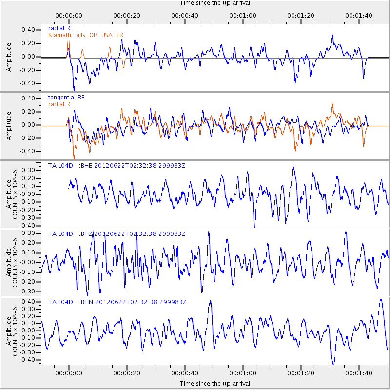
L04D Klamath Falls, OR, USA - Earthquake Result Viewer
*The percent match for this event was below the threshold and hence no stack was calculated.
| Earthquake location: |
South Of Kermadec Islands |
| Earthquake latitude/longitude: |
-32.9/-178.6 |
| Earthquake time(UTC): |
2012/06/22 (174) 02:20:06 GMT |
| Earthquake Depth: |
14 km |
| Earthquake Magnitude: |
5.5 MW, 5.4 MS, 5.3 MB, 5.7 MW |
| Earthquake Catalog/Contributor: |
WHDF/NEIC |
|
| Network: |
TA USArray Transportable Network (new EarthScope stations) |
| Station: |
L04D Klamath Falls, OR, USA |
| Lat/Lon: |
42.22 N/122.30 W |
| Elevation: |
1437 m |
|
| Distance: |
90.9 deg |
| Az: |
38.2 deg |
| Baz: |
224.434 deg |
| Ray Param: |
$rayparam |
*The percent match for this event was below the threshold and hence was not used in the summary stack. |
|
| Radial Match: |
47.770706 % |
| Radial Bump: |
400 |
| Transverse Match: |
52.908497 % |
| Transverse Bump: |
400 |
| SOD ConfigId: |
460165 |
| Insert Time: |
2013-02-12 00:20:55.596 +0000 |
| GWidth: |
2.5 |
| Max Bumps: |
400 |
| Tol: |
0.001 |
|
Signal To Noise
| Channel | StoN | STA | LTA |
| TA:L04D: :BHZ:20120622T02:32:38.299983Z | 1.5378894 | 1.14608504E-7 | 7.452324E-8 |
| TA:L04D: :BHN:20120622T02:32:38.299983Z | 0.7968008 | 9.681954E-8 | 1.2151035E-7 |
| TA:L04D: :BHE:20120622T02:32:38.299983Z | 0.9003422 | 8.468146E-8 | 9.405475E-8 |
| Arrivals |
| Ps | |
| PpPs | |
| PsPs/PpSs | |


