You are here: Home > Network List > CB - China National Seismic Network Stations List
> Station SNY Shenyang,Liaoning Province > Earthquake Result Viewer
SNY Shenyang,Liaoning Province - Earthquake Result Viewer
| Earthquake location: |
Northern Sumatra, Indonesia |
| Earthquake latitude/longitude: |
3.0/97.9 |
| Earthquake time(UTC): |
2012/06/23 (175) 04:34:53 GMT |
| Earthquake Depth: |
95 km |
| Earthquake Magnitude: |
6.3 MB, 6.1 MW, 6.1 MW |
| Earthquake Catalog/Contributor: |
WHDF/NEIC |
|
| Network: |
CB China National Seismic Network |
| Station: |
SNY Shenyang,Liaoning Province |
| Lat/Lon: |
41.83 N/123.58 E |
| Elevation: |
54 m |
|
| Distance: |
45.0 deg |
| Az: |
27.268 deg |
| Baz: |
217.748 deg |
| Ray Param: |
0.07124638 |
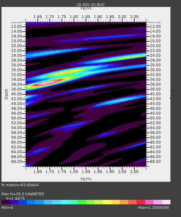
| Estimated Moho Depth: |
35.0 km |
| Estimated Crust Vp/Vs: |
1.69 |
| Assumed Crust Vp: |
6.464 km/s |
| Estimated Crust Vs: |
3.83 km/s |
| Estimated Crust Poisson's Ratio: |
0.23 |
|
| Radial Match: |
93.65644 % |
| Radial Bump: |
290 |
| Transverse Match: |
80.79549 % |
| Transverse Bump: |
400 |
| SOD ConfigId: |
460165 |
| Insert Time: |
2013-02-12 00:36:10.275 +0000 |
| GWidth: |
2.5 |
| Max Bumps: |
400 |
| Tol: |
0.001 |
|

Signal To Noise
| Channel | StoN | STA | LTA |
| CB:SNY:00:BHZ:20120623T04:42:28.539985Z | 51.932045 | 4.8084466E-6 | 9.259113E-8 |
| CB:SNY:00:BHN:20120623T04:42:28.539985Z | 25.01595 | 2.3575467E-6 | 9.424174E-8 |
| CB:SNY:00:BHE:20120623T04:42:28.539985Z | 19.848577 | 2.134342E-6 | 1.0753123E-7 |
| Arrivals |
| Ps | 4.0 SECOND |
| PpPs | 14 SECOND |
| PsPs/PpSs | 18 SECOND |


