You are here: Home > Network List > CB - China National Seismic Network Stations List
> Station DL2 Dalian,Liaoning Province > Earthquake Result Viewer
DL2 Dalian,Liaoning Province - Earthquake Result Viewer
| Earthquake location: |
Northern Sumatra, Indonesia |
| Earthquake latitude/longitude: |
3.0/97.9 |
| Earthquake time(UTC): |
2012/06/23 (175) 04:34:53 GMT |
| Earthquake Depth: |
95 km |
| Earthquake Magnitude: |
6.3 MB, 6.1 MW, 6.1 MW |
| Earthquake Catalog/Contributor: |
WHDF/NEIC |
|
| Network: |
CB China National Seismic Network |
| Station: |
DL2 Dalian,Liaoning Province |
| Lat/Lon: |
38.91 N/121.63 E |
| Elevation: |
65 m |
|
| Distance: |
41.8 deg |
| Az: |
28.128 deg |
| Baz: |
217.115 deg |
| Ray Param: |
0.07326328 |
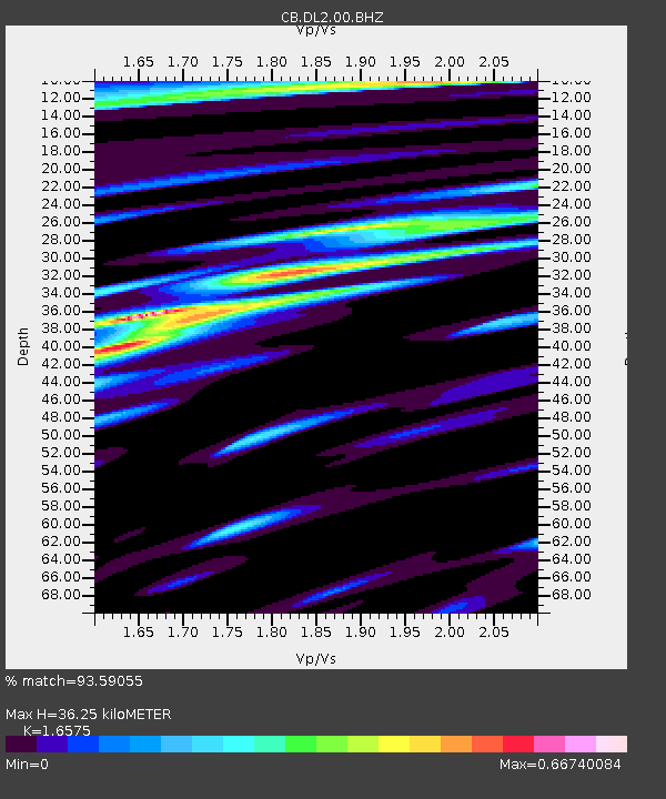
| Estimated Moho Depth: |
36.25 km |
| Estimated Crust Vp/Vs: |
1.66 |
| Assumed Crust Vp: |
6.134 km/s |
| Estimated Crust Vs: |
3.701 km/s |
| Estimated Crust Poisson's Ratio: |
0.21 |
|
| Radial Match: |
93.59055 % |
| Radial Bump: |
260 |
| Transverse Match: |
81.845215 % |
| Transverse Bump: |
400 |
| SOD ConfigId: |
462790 |
| Insert Time: |
2013-02-12 17:00:50.669 +0000 |
| GWidth: |
2.5 |
| Max Bumps: |
400 |
| Tol: |
0.001 |
|

Signal To Noise
| Channel | StoN | STA | LTA |
| CB:DL2:00:BHZ:20120623T04:42:02.69001Z | 38.0092 | 7.862168E-6 | 2.0684905E-7 |
| CB:DL2:00:BHN:20120623T04:42:02.69001Z | 24.032333 | 3.923664E-6 | 1.6326604E-7 |
| CB:DL2:00:BHE:20120623T04:42:02.69001Z | 17.749739 | 2.4801384E-6 | 1.3972816E-7 |
| Arrivals |
| Ps | 4.1 SECOND |
| PpPs | 15 SECOND |
| PsPs/PpSs | 19 SECOND |


