You are here: Home > Network List > IU - Global Seismograph Network (GSN - IRIS/USGS) Stations List
> Station JOHN Johnston Island, USA > Earthquake Result Viewer
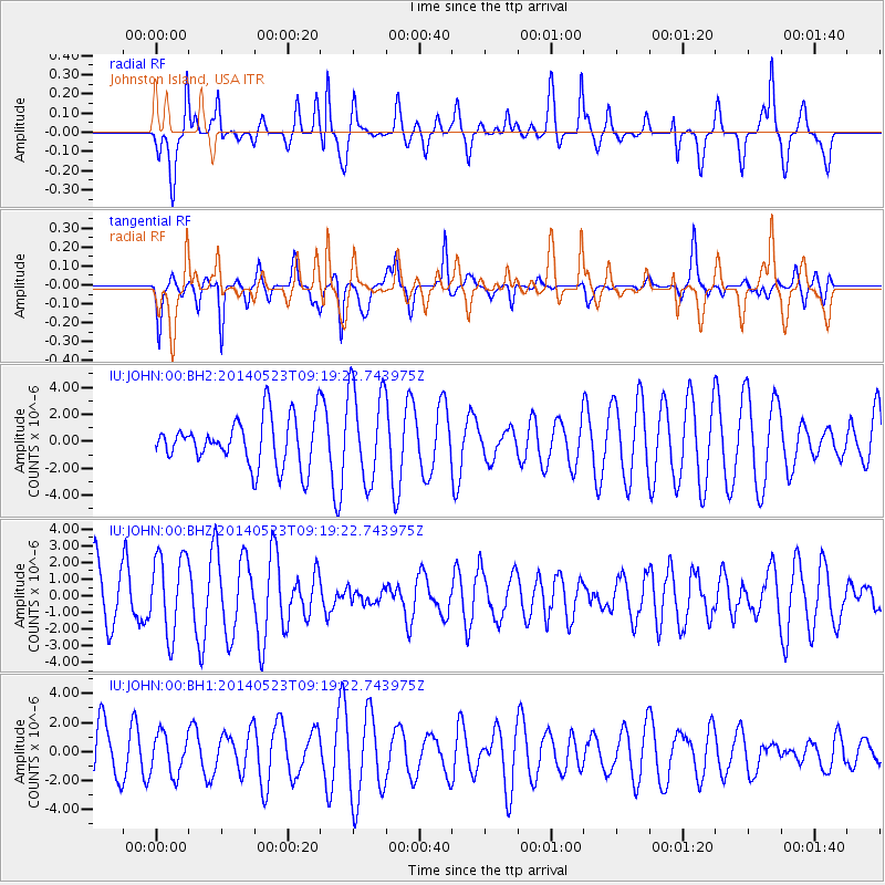
JOHN Johnston Island, USA - Earthquake Result Viewer
*The percent match for this event was below the threshold and hence no stack was calculated.
| Earthquake location: |
Southwest Of Sumatra, Indonesia |
| Earthquake latitude/longitude: |
-7.0/102.6 |
| Earthquake time(UTC): |
2014/05/23 (143) 09:06:56 GMT |
| Earthquake Depth: |
17 km |
| Earthquake Magnitude: |
4.9 MW |
| Earthquake Catalog/Contributor: |
ISC/ISC |
|
| Network: |
IU Global Seismograph Network (GSN - IRIS/USGS) |
| Station: |
JOHN Johnston Island, USA |
| Lat/Lon: |
16.73 N/169.53 W |
| Elevation: |
2.0 m |
|
| Distance: |
89.9 deg |
| Az: |
73.237 deg |
| Baz: |
262.739 deg |
| Ray Param: |
$rayparam |
*The percent match for this event was below the threshold and hence was not used in the summary stack. |
|
| Radial Match: |
56.89403 % |
| Radial Bump: |
398 |
| Transverse Match: |
71.72148 % |
| Transverse Bump: |
335 |
| SOD ConfigId: |
3390531 |
| Insert Time: |
2019-04-12 00:07:31.211 +0000 |
| GWidth: |
2.5 |
| Max Bumps: |
400 |
| Tol: |
0.001 |
|
Signal To Noise
| Channel | StoN | STA | LTA |
| IU:JOHN:00:BHZ:20140523T09:19:22.743975Z | 0.7690542 | 2.406481E-6 | 3.1291436E-6 |
| IU:JOHN:00:BH1:20140523T09:19:22.743975Z | 0.7359273 | 1.3876472E-6 | 1.8855766E-6 |
| IU:JOHN:00:BH2:20140523T09:19:22.743975Z | 2.0118845 | 3.521595E-6 | 1.7503962E-6 |
| Arrivals |
| Ps | |
| PpPs | |
| PsPs/PpSs | |


