You are here: Home > Network List > JP - Japan Meteorological Agency Seismic Network Stations List
> Station JOW Okinawa Kunigami > Earthquake Result Viewer
JOW Okinawa Kunigami - Earthquake Result Viewer
| Earthquake location: |
Southwest Of Sumatra, Indonesia |
| Earthquake latitude/longitude: |
-7.0/102.6 |
| Earthquake time(UTC): |
2014/05/23 (143) 09:06:56 GMT |
| Earthquake Depth: |
17 km |
| Earthquake Magnitude: |
4.9 MW |
| Earthquake Catalog/Contributor: |
ISC/ISC |
|
| Network: |
JP Japan Meteorological Agency Seismic Network |
| Station: |
JOW Okinawa Kunigami |
| Lat/Lon: |
26.84 N/128.27 E |
| Elevation: |
220 m |
|
| Distance: |
41.8 deg |
| Az: |
35.452 deg |
| Baz: |
220.12 deg |
| Ray Param: |
0.07354262 |
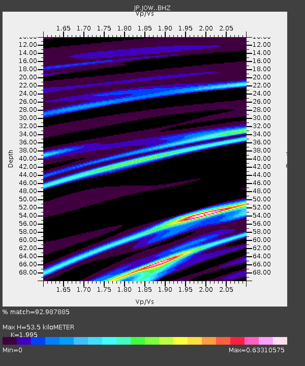
| Estimated Moho Depth: |
53.5 km |
| Estimated Crust Vp/Vs: |
2.00 |
| Assumed Crust Vp: |
6.183 km/s |
| Estimated Crust Vs: |
3.099 km/s |
| Estimated Crust Poisson's Ratio: |
0.33 |
|
| Radial Match: |
92.987885 % |
| Radial Bump: |
199 |
| Transverse Match: |
72.591835 % |
| Transverse Bump: |
400 |
| SOD ConfigId: |
3390531 |
| Insert Time: |
2019-04-12 00:07:37.501 +0000 |
| GWidth: |
2.5 |
| Max Bumps: |
400 |
| Tol: |
0.001 |
|

Signal To Noise
| Channel | StoN | STA | LTA |
| JP:JOW: :BHZ:20140523T09:14:13.949999Z | 2.386635 | 4.6962998E-7 | 1.9677495E-7 |
| JP:JOW: :BHN:20140523T09:14:13.949999Z | 2.3894796 | 3.7464082E-7 | 1.5678762E-7 |
| JP:JOW: :BHE:20140523T09:14:13.949999Z | 3.3571496 | 6.725985E-7 | 2.003481E-7 |
| Arrivals |
| Ps | 9.1 SECOND |
| PpPs | 25 SECOND |
| PsPs/PpSs | 34 SECOND |


