You are here: Home > Network List > IC - New China Digital Seismograph Network Stations List
> Station MDJ Mudanjiang, Heilongjiang Province, China > Earthquake Result Viewer
MDJ Mudanjiang, Heilongjiang Province, China - Earthquake Result Viewer

| Earthquake location: |
Northern Sumatra, Indonesia |
| Earthquake latitude/longitude: |
3.0/97.9 |
| Earthquake time(UTC): |
2012/06/23 (175) 04:34:53 GMT |
| Earthquake Depth: |
95 km |
| Earthquake Magnitude: |
6.3 MB, 6.1 MW, 6.1 MW |
| Earthquake Catalog/Contributor: |
WHDF/NEIC |
|
| Network: |
IC New China Digital Seismograph Network |
| Station: |
MDJ Mudanjiang, Heilongjiang Province, China |
| Lat/Lon: |
44.62 N/129.59 E |
| Elevation: |
270 m |
|
| Distance: |
50.0 deg |
| Az: |
29.348 deg |
| Baz: |
223.261 deg |
| Ray Param: |
0.06806474 |
| Estimated Moho Depth: |
55.25 km |
| Estimated Crust Vp/Vs: |
2.04 |
| Assumed Crust Vp: |
6.459 km/s |
| Estimated Crust Vs: |
3.174 km/s |
| Estimated Crust Poisson's Ratio: |
0.34 |
|
| Radial Match: |
95.76577 % |
| Radial Bump: |
400 |
| Transverse Match: |
86.547935 % |
| Transverse Bump: |
400 |
| SOD ConfigId: |
462790 |
| Insert Time: |
2013-02-12 17:02:44.556 +0000 |
| GWidth: |
2.5 |
| Max Bumps: |
400 |
| Tol: |
0.001 |
|
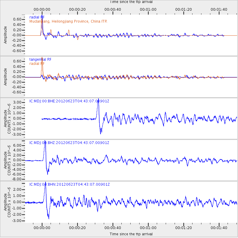
Signal To Noise
| Channel | StoN | STA | LTA |
| IC:MDJ:00:BHZ:20120623T04:43:07.00901Z | 55.24335 | 3.714923E-6 | 6.724652E-8 |
| IC:MDJ:00:BHN:20120623T04:43:07.00901Z | 29.341005 | 1.4974247E-6 | 5.103522E-8 |
| IC:MDJ:00:BHE:20120623T04:43:07.00901Z | 31.621214 | 1.712247E-6 | 5.414868E-8 |
| Arrivals |
| Ps | 9.3 SECOND |
| PpPs | 25 SECOND |
| PsPs/PpSs | 34 SECOND |


