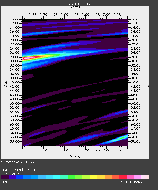
SSB Saint Sauveur Badole, France - Earthquake Result Viewer

Earthquake location: Off W Coast Of Northern Sumatra
Earthquake latitude/longitude: 2.8/96.0
Earthquake time(UTC): 2008/02/20 (051) 08:08:30 GMT
Earthquake Depth: 26 km
Earthquake Magnitude: 6.5 MB, 7.5 MS, 7.4 MW, 7.4 MW
Earthquake Catalog/Contributor: WHDF/NEIC
Network: G GEOSCOPE
Station: SSB Saint Sauveur Badole, France
Lat/Lon: 45.28 N/4.54 E
Elevation: 700 m
Distance: 89.1 deg
Az: 315.096 deg
Baz: 87.052 deg
Ray Param: 0.04210049
Estimated Moho Depth: 28.5 km
Estimated Crust Vp/Vs: 1.61
Assumed Crust Vp: 6.1 km/s
Estimated Crust Vs: 3.801 km/s
Estimated Crust Poisson's Ratio: 0.18
Radial Match: 94.71955 %
Radial Bump: 311
Transverse Match: 76.544044 %
Transverse Bump: 400
SOD ConfigId: 2564
Insert Time: 2010-02-27 00:05:42.185 +0000
GWidth: 2.5
Max Bumps: 400
Tol: 0.001

Signal To Noise

ChannelStoNSTALTA
G:SSB:00:BHN:20080220T08:20:51.800029Z0.81794289.706286E-81.1866705E-7
G:SSB:00:BHE:20080220T08:20:51.800029Z3.5357575.4774426E-71.549157E-7
G:SSB:00:BHZ:20080220T08:20:51.800029Z5.69506747.25949E-71.2746979E-7
Arrivals
Ps2.9 SECOND
PpPs12 SECOND
PsPs/PpSs15 SECOND