You are here: Home > Network List > CI - Caltech Regional Seismic Network Stations List
> Station PDM Parker Dam, Lake Havasu City, AZ, USA > Earthquake Result Viewer
PDM Parker Dam, Lake Havasu City, AZ, USA - Earthquake Result Viewer
| Earthquake location: |
Near East Coast Of Kamchatka |
| Earthquake latitude/longitude: |
57.6/163.2 |
| Earthquake time(UTC): |
2012/06/24 (176) 03:15:01 GMT |
| Earthquake Depth: |
10 km |
| Earthquake Magnitude: |
5.8 MB, 5.8 MS, 6.0 MW, 6.1 MW |
| Earthquake Catalog/Contributor: |
WHDF/NEIC |
|
| Network: |
CI Caltech Regional Seismic Network |
| Station: |
PDM Parker Dam, Lake Havasu City, AZ, USA |
| Lat/Lon: |
34.30 N/114.14 W |
| Elevation: |
144 m |
|
| Distance: |
58.0 deg |
| Az: |
75.46 deg |
| Baz: |
320.985 deg |
| Ray Param: |
0.06311863 |
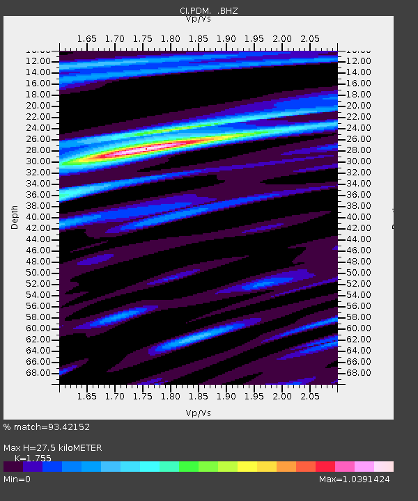
| Estimated Moho Depth: |
27.5 km |
| Estimated Crust Vp/Vs: |
1.75 |
| Assumed Crust Vp: |
6.276 km/s |
| Estimated Crust Vs: |
3.576 km/s |
| Estimated Crust Poisson's Ratio: |
0.26 |
|
| Radial Match: |
93.42152 % |
| Radial Bump: |
400 |
| Transverse Match: |
82.81183 % |
| Transverse Bump: |
400 |
| SOD ConfigId: |
462790 |
| Insert Time: |
2013-02-12 17:15:25.598 +0000 |
| GWidth: |
2.5 |
| Max Bumps: |
400 |
| Tol: |
0.001 |
|

Signal To Noise
| Channel | StoN | STA | LTA |
| CI:PDM: :BHZ:20120624T03:24:23.095002Z | 10.994074 | 7.7054136E-7 | 7.0086976E-8 |
| CI:PDM: :BHN:20120624T03:24:23.095002Z | 4.515812 | 2.9547263E-7 | 6.5430676E-8 |
| CI:PDM: :BHE:20120624T03:24:23.095002Z | 3.4811761 | 2.2537189E-7 | 6.4740156E-8 |
| Arrivals |
| Ps | 3.5 SECOND |
| PpPs | 12 SECOND |
| PsPs/PpSs | 15 SECOND |


