ABKT Alibek, Turkmenistan - Earthquake Result Viewer
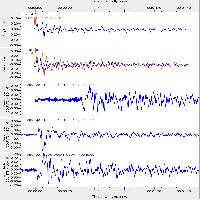
Earthquake location: Near East Coast Of Kamchatka
Earthquake latitude/longitude: 57.6/163.2
Earthquake time(UTC): 2012/06/24 (176) 03:15:01 GMT
Earthquake Depth: 10 km
Earthquake Magnitude: 5.8 MB, 5.8 MS, 6.0 MW, 6.1 MW
Earthquake Catalog/Contributor: WHDF/NEIC
Network: II Global Seismograph Network (GSN - IRIS/IDA)
Station: ABKT Alibek, Turkmenistan
Lat/Lon: 37.93 N/58.12 E
Elevation: 678 m
Distance: 66.1 deg
Az: 303.37 deg
Baz: 34.652 deg
Ray Param: 0.057836417
Estimated Moho Depth: 12.75 km
Estimated Crust Vp/Vs: 1.62
Assumed Crust Vp: 6.53 km/s
Estimated Crust Vs: 4.031 km/s
Estimated Crust Poisson's Ratio: 0.19
Radial Match: 94.4968 %
Radial Bump: 400
Transverse Match: 89.32628 %
Transverse Bump: 400
SOD ConfigId: 462790
Insert Time: 2013-02-12 17:18:11.384 +0000
GWidth: 2.5
Max Bumps: 400
Tol: 0.001

Signal To Noise

ChannelStoNSTALTA
II:ABKT:00:BHZ:20120624T03:25:17.284028Z21.1337381.4676438E-66.9445534E-8
II:ABKT:00:BHN:20120624T03:25:17.284028Z6.21144153.5600144E-75.731382E-8
II:ABKT:00:BHE:20120624T03:25:17.284028Z4.9737943.1979945E-76.4296884E-8
Arrivals
Ps1.3 SECOND
PpPs4.9 SECOND
PsPs/PpSs6.2 SECOND