You are here: Home > Network List > G - GEOSCOPE Stations List
> Station SSB Saint Sauveur Badole, France > Earthquake Result Viewer
SSB Saint Sauveur Badole, France - Earthquake Result Viewer

| Earthquake location: |
Sudan |
| Earthquake latitude/longitude: |
5.0/32.1 |
| Earthquake time(UTC): |
1990/05/20 (140) 02:21:59 GMT |
| Earthquake Depth: |
7.0 km |
| Earthquake Magnitude: |
6.6 MB, 7.2 MS |
| Earthquake Catalog/Contributor: |
WHDF/NEIC |
|
| Network: |
G GEOSCOPE |
| Station: |
SSB Saint Sauveur Badole, France |
| Lat/Lon: |
45.28 N/4.54 E |
| Elevation: |
700 m |
|
| Distance: |
46.7 deg |
| Az: |
333.342 deg |
| Baz: |
140.725 deg |
| Ray Param: |
0.070462644 |
| Estimated Moho Depth: |
29.5 km |
| Estimated Crust Vp/Vs: |
1.62 |
| Assumed Crust Vp: |
6.1 km/s |
| Estimated Crust Vs: |
3.76 km/s |
| Estimated Crust Poisson's Ratio: |
0.19 |
|
| Radial Match: |
92.96572 % |
| Radial Bump: |
324 |
| Transverse Match: |
90.791245 % |
| Transverse Bump: |
345 |
| SOD ConfigId: |
16938 |
| Insert Time: |
2010-02-27 00:05:53.611 +0000 |
| GWidth: |
2.5 |
| Max Bumps: |
400 |
| Tol: |
0.001 |
|
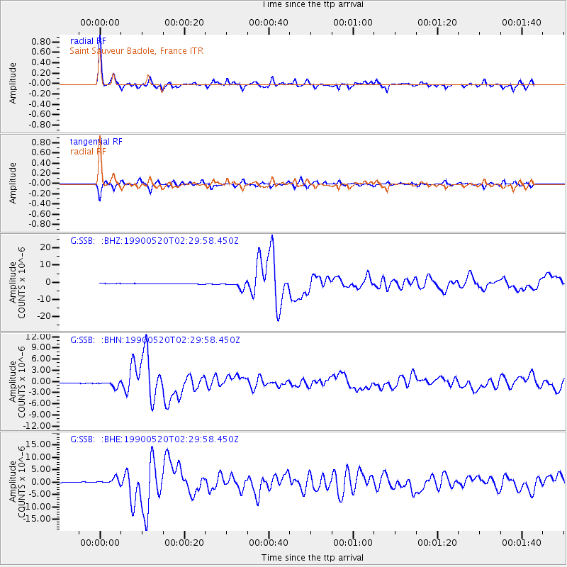
Signal To Noise
| Channel | StoN | STA | LTA |
| G:SSB: :BHN:19900520T02:29:58.450Z | 13.753196 | 7.9770615E-7 | 5.800151E-8 |
| G:SSB: :BHE:19900520T02:29:58.450Z | 9.961557 | 1.2519932E-6 | 1.2568248E-7 |
| G:SSB: :BHZ:19900520T02:29:58.450Z | 15.396427 | 1.995543E-6 | 1.2961078E-7 |
| Arrivals |
| Ps | 3.2 SECOND |
| PpPs | 12 SECOND |
| PsPs/PpSs | 15 SECOND |


