You are here: Home > Network List > LD - Lamont-Doherty Cooperative Seismographic Network Stations List
> Station FRNY Flat Rock, Altona, NY > Earthquake Result Viewer
FRNY Flat Rock, Altona, NY - Earthquake Result Viewer
| Earthquake location: |
Near East Coast Of Kamchatka |
| Earthquake latitude/longitude: |
57.6/163.2 |
| Earthquake time(UTC): |
2012/06/24 (176) 03:15:01 GMT |
| Earthquake Depth: |
10 km |
| Earthquake Magnitude: |
5.8 MB, 5.8 MS, 6.0 MW, 6.1 MW |
| Earthquake Catalog/Contributor: |
WHDF/NEIC |
|
| Network: |
LD Lamont-Doherty Cooperative Seismographic Network |
| Station: |
FRNY Flat Rock, Altona, NY |
| Lat/Lon: |
44.83 N/73.59 W |
| Elevation: |
242 m |
|
| Distance: |
67.5 deg |
| Az: |
40.104 deg |
| Baz: |
330.828 deg |
| Ray Param: |
0.05690092 |
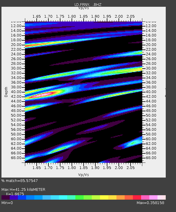
| Estimated Moho Depth: |
41.25 km |
| Estimated Crust Vp/Vs: |
1.67 |
| Assumed Crust Vp: |
6.419 km/s |
| Estimated Crust Vs: |
3.85 km/s |
| Estimated Crust Poisson's Ratio: |
0.22 |
|
| Radial Match: |
85.57547 % |
| Radial Bump: |
400 |
| Transverse Match: |
68.56945 % |
| Transverse Bump: |
400 |
| SOD ConfigId: |
462790 |
| Insert Time: |
2013-02-12 17:23:00.360 +0000 |
| GWidth: |
2.5 |
| Max Bumps: |
400 |
| Tol: |
0.001 |
|

Signal To Noise
| Channel | StoN | STA | LTA |
| LD:FRNY: :BHZ:20120624T03:25:26.319978Z | 5.7135115 | 5.6064397E-7 | 9.8125994E-8 |
| LD:FRNY: :BHN:20120624T03:25:26.319978Z | 2.7761593 | 1.8503064E-7 | 6.664986E-8 |
| LD:FRNY: :BHE:20120624T03:25:26.319978Z | 1.9620405 | 1.1400156E-7 | 5.810357E-8 |
| Arrivals |
| Ps | 4.5 SECOND |
| PpPs | 16 SECOND |
| PsPs/PpSs | 21 SECOND |


