You are here: Home > Network List > G - GEOSCOPE Stations List
> Station SSB Saint Sauveur Badole, France > Earthquake Result Viewer
SSB Saint Sauveur Badole, France - Earthquake Result Viewer

| Earthquake location: |
Southern Iran |
| Earthquake latitude/longitude: |
28.2/55.5 |
| Earthquake time(UTC): |
1990/11/06 (310) 18:45:54 GMT |
| Earthquake Depth: |
25 km |
| Earthquake Magnitude: |
6.2 MB, 6.8 MS, 6.7 UNKNOWN |
| Earthquake Catalog/Contributor: |
WHDF/NEIC |
|
| Network: |
G GEOSCOPE |
| Station: |
SSB Saint Sauveur Badole, France |
| Lat/Lon: |
45.28 N/4.54 E |
| Elevation: |
700 m |
|
| Distance: |
43.4 deg |
| Az: |
307.159 deg |
| Baz: |
95.148 deg |
| Ray Param: |
0.072506554 |
| Estimated Moho Depth: |
28.25 km |
| Estimated Crust Vp/Vs: |
1.62 |
| Assumed Crust Vp: |
6.1 km/s |
| Estimated Crust Vs: |
3.777 km/s |
| Estimated Crust Poisson's Ratio: |
0.19 |
|
| Radial Match: |
89.73457 % |
| Radial Bump: |
384 |
| Transverse Match: |
62.13723 % |
| Transverse Bump: |
400 |
| SOD ConfigId: |
16938 |
| Insert Time: |
2010-02-27 00:06:03.104 +0000 |
| GWidth: |
2.5 |
| Max Bumps: |
400 |
| Tol: |
0.001 |
|
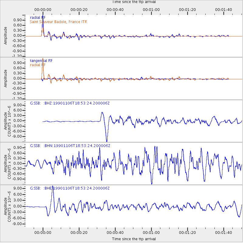
Signal To Noise
| Channel | StoN | STA | LTA |
| G:SSB: :BHN:19901106T18:53:24.200006Z | 2.1987069 | 1.3529579E-7 | 6.153426E-8 |
| G:SSB: :BHE:19901106T18:53:24.200006Z | 23.655106 | 2.394251E-6 | 1.0121497E-7 |
| G:SSB: :BHZ:19901106T18:53:24.200006Z | 22.640406 | 2.7599426E-6 | 1.2190341E-7 |
| Arrivals |
| Ps | 3.0 SECOND |
| PpPs | 11 SECOND |
| PsPs/PpSs | 14 SECOND |


