You are here: Home > Network List > G - GEOSCOPE Stations List
> Station SSB Saint Sauveur Badole, France > Earthquake Result Viewer
SSB Saint Sauveur Badole, France - Earthquake Result Viewer
| Earthquake location: |
Komandorskiye Ostrova Region |
| Earthquake latitude/longitude: |
53.5/169.9 |
| Earthquake time(UTC): |
1990/11/06 (310) 20:14:30 GMT |
| Earthquake Depth: |
32 km |
| Earthquake Magnitude: |
6.4 MB, 7.0 MS, 6.8 UNKNOWN |
| Earthquake Catalog/Contributor: |
WHDF/NEIC |
|
| Network: |
G GEOSCOPE |
| Station: |
SSB Saint Sauveur Badole, France |
| Lat/Lon: |
45.28 N/4.54 E |
| Elevation: |
700 m |
|
| Distance: |
80.8 deg |
| Az: |
349.605 deg |
| Baz: |
8.788 deg |
| Ray Param: |
0.04796336 |
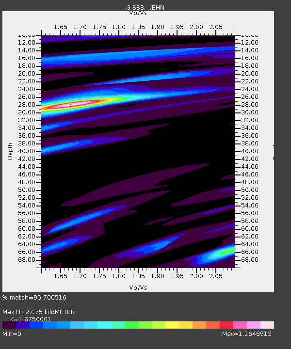
| Estimated Moho Depth: |
27.75 km |
| Estimated Crust Vp/Vs: |
1.68 |
| Assumed Crust Vp: |
6.1 km/s |
| Estimated Crust Vs: |
3.642 km/s |
| Estimated Crust Poisson's Ratio: |
0.22 |
|
| Radial Match: |
95.700516 % |
| Radial Bump: |
365 |
| Transverse Match: |
88.39394 % |
| Transverse Bump: |
400 |
| SOD ConfigId: |
16938 |
| Insert Time: |
2010-02-27 00:06:04.504 +0000 |
| GWidth: |
2.5 |
| Max Bumps: |
400 |
| Tol: |
0.001 |
|

Signal To Noise
| Channel | StoN | STA | LTA |
| G:SSB: :BHN:19901106T20:26:10.400Z | 3.5338705 | 1.0634946E-6 | 3.0094327E-7 |
| G:SSB: :BHE:19901106T20:26:10.400Z | 1.7216899 | 6.859764E-7 | 3.98432E-7 |
| G:SSB: :BHZ:19901106T20:26:10.400Z | 6.8140674 | 2.5905604E-6 | 3.8017828E-7 |
| Arrivals |
| Ps | 3.2 SECOND |
| PpPs | 12 SECOND |
| PsPs/PpSs | 15 SECOND |


