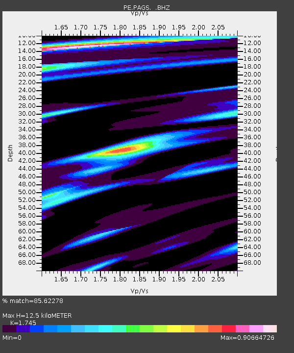
PAGS PA Geological Survey - Earthquake Result Viewer

Earthquake location: Near East Coast Of Kamchatka
Earthquake latitude/longitude: 57.6/163.2
Earthquake time(UTC): 2012/06/24 (176) 03:15:01 GMT
Earthquake Depth: 10 km
Earthquake Magnitude: 5.8 MB, 5.8 MS, 6.0 MW, 6.1 MW
Earthquake Catalog/Contributor: WHDF/NEIC
Network: PE Penn State Network
Station: PAGS PA Geological Survey
Lat/Lon: 40.23 N/76.72 W
Elevation: 120 m
Distance: 70.4 deg
Az: 44.688 deg
Baz: 330.362 deg
Ray Param: 0.055009995
Estimated Moho Depth: 12.5 km
Estimated Crust Vp/Vs: 1.75
Assumed Crust Vp: 6.121 km/s
Estimated Crust Vs: 3.507 km/s
Estimated Crust Poisson's Ratio: 0.26
Radial Match: 85.62278 %
Radial Bump: 355
Transverse Match: 63.693386 %
Transverse Bump: 400
SOD ConfigId: 462790
Insert Time: 2013-02-12 17:32:11.662 +0000
GWidth: 2.5
Max Bumps: 400
Tol: 0.001

Signal To Noise

ChannelStoNSTALTA
PE:PAGS: :BHZ:20120624T03:25:44.139985Z6.4517935.8804767E-79.114484E-8
PE:PAGS: :BHN:20120624T03:25:44.139985Z2.6275112.2185358E-78.443488E-8
PE:PAGS: :BHE:20120624T03:25:44.139985Z3.41534971.6709811E-74.892562E-8
Arrivals
Ps1.6 SECOND
PpPs5.4 SECOND
PsPs/PpSs7.0 SECOND