You are here: Home > Network List > TA - USArray Transportable Network (new EarthScope stations) Stations List
> Station W18A Petrified Forest, AZ, USA > Earthquake Result Viewer
W18A Petrified Forest, AZ, USA - Earthquake Result Viewer
| Earthquake location: |
Near East Coast Of Kamchatka |
| Earthquake latitude/longitude: |
57.6/163.2 |
| Earthquake time(UTC): |
2012/06/24 (176) 03:15:01 GMT |
| Earthquake Depth: |
10 km |
| Earthquake Magnitude: |
5.8 MB, 5.8 MS, 6.0 MW, 6.1 MW |
| Earthquake Catalog/Contributor: |
WHDF/NEIC |
|
| Network: |
TA USArray Transportable Network (new EarthScope stations) |
| Station: |
W18A Petrified Forest, AZ, USA |
| Lat/Lon: |
35.12 N/109.74 W |
| Elevation: |
1750 m |
|
| Distance: |
59.7 deg |
| Az: |
71.559 deg |
| Baz: |
321.464 deg |
| Ray Param: |
0.062043395 |
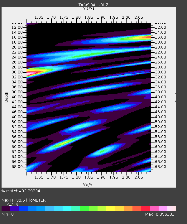
| Estimated Moho Depth: |
30.5 km |
| Estimated Crust Vp/Vs: |
1.60 |
| Assumed Crust Vp: |
6.496 km/s |
| Estimated Crust Vs: |
4.06 km/s |
| Estimated Crust Poisson's Ratio: |
0.18 |
|
| Radial Match: |
93.29234 % |
| Radial Bump: |
364 |
| Transverse Match: |
83.23575 % |
| Transverse Bump: |
400 |
| SOD ConfigId: |
462790 |
| Insert Time: |
2013-02-12 17:35:15.674 +0000 |
| GWidth: |
2.5 |
| Max Bumps: |
400 |
| Tol: |
0.001 |
|

Signal To Noise
| Channel | StoN | STA | LTA |
| TA:W18A: :BHZ:20120624T03:24:34.475007Z | 7.064504 | 5.6144177E-7 | 7.947362E-8 |
| TA:W18A: :BHN:20120624T03:24:34.475007Z | 3.28943 | 1.8435658E-7 | 5.6045145E-8 |
| TA:W18A: :BHE:20120624T03:24:34.475007Z | 2.4313538 | 1.4477729E-7 | 5.9545957E-8 |
| Arrivals |
| Ps | 3.0 SECOND |
| PpPs | 12 SECOND |
| PsPs/PpSs | 15 SECOND |


