You are here: Home > Network List > TA - USArray Transportable Network (new EarthScope stations) Stations List
> Station 121A Cookes Peak, Deming, NM, USA > Earthquake Result Viewer
121A Cookes Peak, Deming, NM, USA - Earthquake Result Viewer
| Earthquake location: |
Near East Coast Of Kamchatka |
| Earthquake latitude/longitude: |
57.6/163.2 |
| Earthquake time(UTC): |
2012/06/24 (176) 03:15:01 GMT |
| Earthquake Depth: |
10 km |
| Earthquake Magnitude: |
5.8 MB, 5.8 MS, 6.0 MW, 6.1 MW |
| Earthquake Catalog/Contributor: |
WHDF/NEIC |
|
| Network: |
TA USArray Transportable Network (new EarthScope stations) |
| Station: |
121A Cookes Peak, Deming, NM, USA |
| Lat/Lon: |
32.53 N/107.79 W |
| Elevation: |
1652 m |
|
| Distance: |
62.7 deg |
| Az: |
71.905 deg |
| Baz: |
322.712 deg |
| Ray Param: |
0.060061246 |
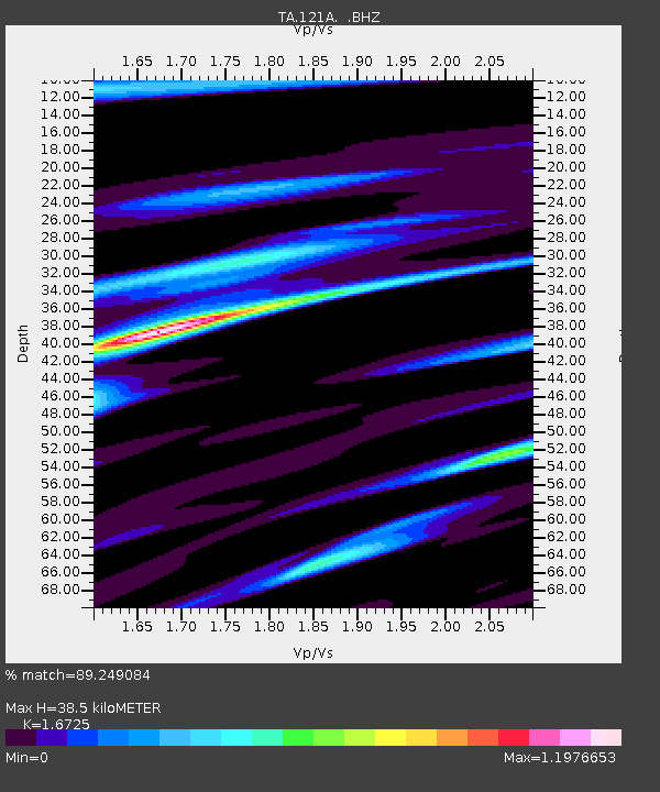
| Estimated Moho Depth: |
38.5 km |
| Estimated Crust Vp/Vs: |
1.67 |
| Assumed Crust Vp: |
6.502 km/s |
| Estimated Crust Vs: |
3.887 km/s |
| Estimated Crust Poisson's Ratio: |
0.22 |
|
| Radial Match: |
89.249084 % |
| Radial Bump: |
400 |
| Transverse Match: |
80.13783 % |
| Transverse Bump: |
400 |
| SOD ConfigId: |
462790 |
| Insert Time: |
2013-02-12 17:35:40.392 +0000 |
| GWidth: |
2.5 |
| Max Bumps: |
400 |
| Tol: |
0.001 |
|

Signal To Noise
| Channel | StoN | STA | LTA |
| TA:121A: :BHZ:20120624T03:24:54.999971Z | 8.3898 | 4.4707363E-7 | 5.3287753E-8 |
| TA:121A: :BHN:20120624T03:24:54.999971Z | 2.6891983 | 1.414184E-7 | 5.2587566E-8 |
| TA:121A: :BHE:20120624T03:24:54.999971Z | 2.3381927 | 1.3145997E-7 | 5.62229E-8 |
| Arrivals |
| Ps | 4.2 SECOND |
| PpPs | 15 SECOND |
| PsPs/PpSs | 19 SECOND |


