You are here: Home > Network List > TA - USArray Transportable Network (new EarthScope stations) Stations List
> Station SFIN Lafayette, IN, USA > Earthquake Result Viewer
SFIN Lafayette, IN, USA - Earthquake Result Viewer
| Earthquake location: |
Near East Coast Of Kamchatka |
| Earthquake latitude/longitude: |
57.6/163.2 |
| Earthquake time(UTC): |
2012/06/24 (176) 03:15:01 GMT |
| Earthquake Depth: |
10 km |
| Earthquake Magnitude: |
5.8 MB, 5.8 MS, 6.0 MW, 6.1 MW |
| Earthquake Catalog/Contributor: |
WHDF/NEIC |
|
| Network: |
TA USArray Transportable Network (new EarthScope stations) |
| Station: |
SFIN Lafayette, IN, USA |
| Lat/Lon: |
40.38 N/87.10 W |
| Elevation: |
165 m |
|
| Distance: |
66.1 deg |
| Az: |
51.87 deg |
| Baz: |
326.333 deg |
| Ray Param: |
0.057836283 |
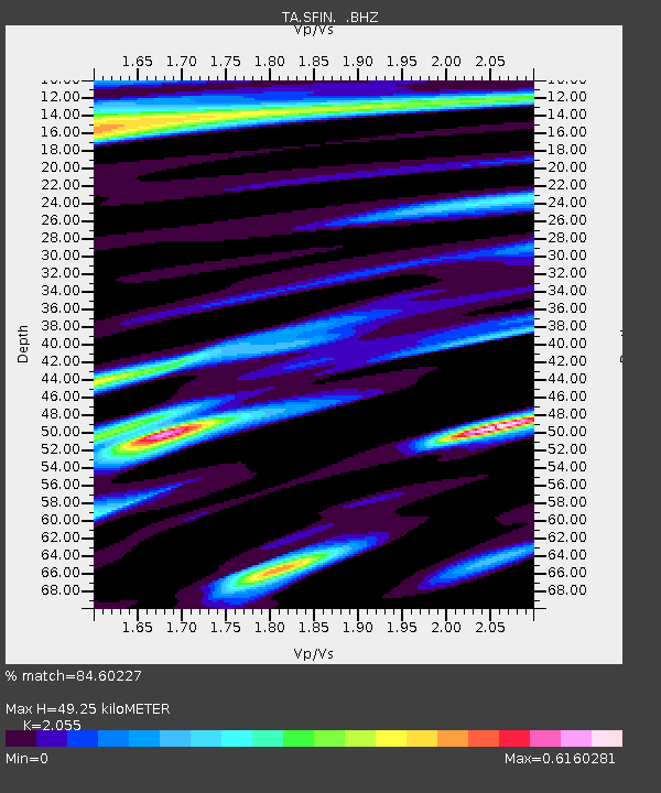
| Estimated Moho Depth: |
49.25 km |
| Estimated Crust Vp/Vs: |
2.06 |
| Assumed Crust Vp: |
6.498 km/s |
| Estimated Crust Vs: |
3.162 km/s |
| Estimated Crust Poisson's Ratio: |
0.34 |
|
| Radial Match: |
84.60227 % |
| Radial Bump: |
400 |
| Transverse Match: |
44.15171 % |
| Transverse Bump: |
400 |
| SOD ConfigId: |
462790 |
| Insert Time: |
2013-02-12 17:37:03.155 +0000 |
| GWidth: |
2.5 |
| Max Bumps: |
400 |
| Tol: |
0.001 |
|
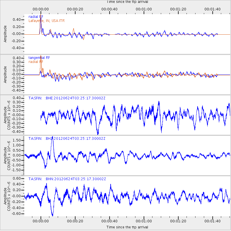
Signal To Noise
| Channel | StoN | STA | LTA |
| TA:SFIN: :BHZ:20120624T03:25:17.30002Z | 6.629612 | 5.5468144E-7 | 8.366725E-8 |
| TA:SFIN: :BHN:20120624T03:25:17.30002Z | 3.0081196 | 2.0916957E-7 | 6.953499E-8 |
| TA:SFIN: :BHE:20120624T03:25:17.30002Z | 2.4717643 | 2.1288427E-7 | 8.612644E-8 |
| Arrivals |
| Ps | 8.3 SECOND |
| PpPs | 22 SECOND |
| PsPs/PpSs | 31 SECOND |


