You are here: Home > Network List > G - GEOSCOPE Stations List
> Station SSB Saint Sauveur Badole, France > Earthquake Result Viewer
SSB Saint Sauveur Badole, France - Earthquake Result Viewer
| Earthquake location: |
Alaska Peninsula |
| Earthquake latitude/longitude: |
54.5/-161.6 |
| Earthquake time(UTC): |
1991/05/30 (150) 13:17:44 GMT |
| Earthquake Depth: |
47 km |
| Earthquake Magnitude: |
6.2 MB, 6.7 MS, 6.8 UNKNOWN |
| Earthquake Catalog/Contributor: |
WHDF/NEIC |
|
| Network: |
G GEOSCOPE |
| Station: |
SSB Saint Sauveur Badole, France |
| Lat/Lon: |
45.28 N/4.54 E |
| Elevation: |
700 m |
|
| Distance: |
79.9 deg |
| Az: |
9.901 deg |
| Baz: |
351.838 deg |
| Ray Param: |
0.048582833 |
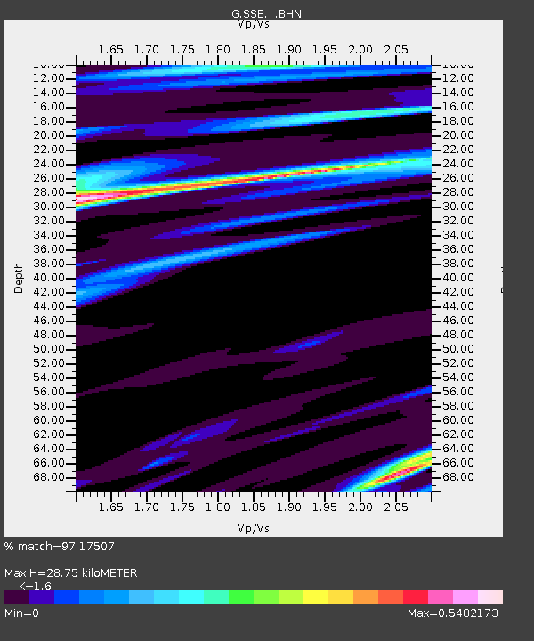
| Estimated Moho Depth: |
28.75 km |
| Estimated Crust Vp/Vs: |
1.60 |
| Assumed Crust Vp: |
6.1 km/s |
| Estimated Crust Vs: |
3.812 km/s |
| Estimated Crust Poisson's Ratio: |
0.18 |
|
| Radial Match: |
97.17507 % |
| Radial Bump: |
400 |
| Transverse Match: |
87.09496 % |
| Transverse Bump: |
400 |
| SOD ConfigId: |
16938 |
| Insert Time: |
2010-02-27 00:06:16.018 +0000 |
| GWidth: |
2.5 |
| Max Bumps: |
400 |
| Tol: |
0.001 |
|

Signal To Noise
| Channel | StoN | STA | LTA |
| G:SSB: :BHN:19910530T13:29:16.750024Z | 15.309571 | 5.6327724E-7 | 3.679249E-8 |
| G:SSB: :BHE:19910530T13:29:16.750024Z | 1.061956 | 4.338965E-8 | 4.0858236E-8 |
| G:SSB: :BHZ:19910530T13:29:16.750024Z | 27.765074 | 1.5735294E-6 | 5.6672977E-8 |
| Arrivals |
| Ps | 2.9 SECOND |
| PpPs | 12 SECOND |
| PsPs/PpSs | 15 SECOND |


