You are here: Home > Network List > G - GEOSCOPE Stations List
> Station SSB Saint Sauveur Badole, France > Earthquake Result Viewer
SSB Saint Sauveur Badole, France - Earthquake Result Viewer

| Earthquake location: |
Central Peru |
| Earthquake latitude/longitude: |
-13.3/-72.4 |
| Earthquake time(UTC): |
1991/07/06 (187) 12:19:45 GMT |
| Earthquake Depth: |
85 km |
| Earthquake Magnitude: |
6.3 MB |
| Earthquake Catalog/Contributor: |
WHDF/NEIC |
|
| Network: |
G GEOSCOPE |
| Station: |
SSB Saint Sauveur Badole, France |
| Lat/Lon: |
45.28 N/4.54 E |
| Elevation: |
700 m |
|
| Distance: |
90.4 deg |
| Az: |
43.461 deg |
| Baz: |
251.529 deg |
| Ray Param: |
0.04166089 |
| Estimated Moho Depth: |
10.0 km |
| Estimated Crust Vp/Vs: |
1.97 |
| Assumed Crust Vp: |
6.1 km/s |
| Estimated Crust Vs: |
3.104 km/s |
| Estimated Crust Poisson's Ratio: |
0.33 |
|
| Radial Match: |
92.09096 % |
| Radial Bump: |
400 |
| Transverse Match: |
88.007706 % |
| Transverse Bump: |
400 |
| SOD ConfigId: |
16938 |
| Insert Time: |
2010-02-27 00:06:22.042 +0000 |
| GWidth: |
2.5 |
| Max Bumps: |
400 |
| Tol: |
0.001 |
|
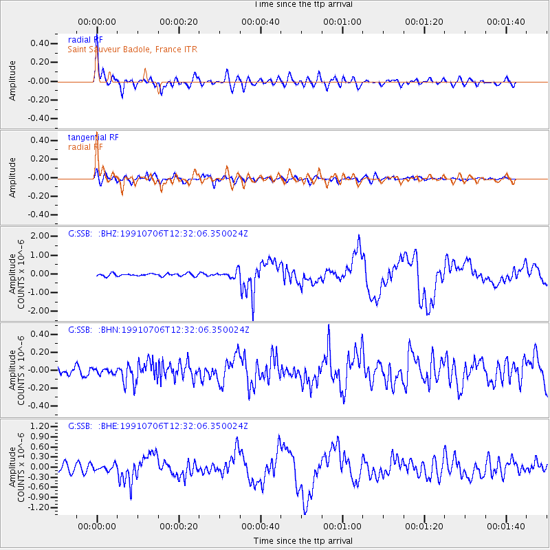
Signal To Noise
| Channel | StoN | STA | LTA |
| G:SSB: :BHN:19910706T12:32:06.350024Z | 0.6125546 | 2.9268618E-8 | 4.778124E-8 |
| G:SSB: :BHE:19910706T12:32:06.350024Z | 0.94044256 | 8.271067E-8 | 8.794866E-8 |
| G:SSB: :BHZ:19910706T12:32:06.350024Z | 2.805631 | 1.8999026E-7 | 6.771748E-8 |
| Arrivals |
| Ps | 1.6 SECOND |
| PpPs | 4.8 SECOND |
| PsPs/PpSs | 6.4 SECOND |


