You are here: Home > Network List > TA - USArray Transportable Network (new EarthScope stations) Stations List
> Station K02D Willamette Meridian, OR, USA > Earthquake Result Viewer
K02D Willamette Meridian, OR, USA - Earthquake Result Viewer
| Earthquake location: |
Near East Coast Of Kamchatka |
| Earthquake latitude/longitude: |
57.6/163.2 |
| Earthquake time(UTC): |
2012/06/24 (176) 03:15:01 GMT |
| Earthquake Depth: |
10 km |
| Earthquake Magnitude: |
5.8 MB, 5.8 MS, 6.0 MW, 6.1 MW |
| Earthquake Catalog/Contributor: |
WHDF/NEIC |
|
| Network: |
TA USArray Transportable Network (new EarthScope stations) |
| Station: |
K02D Willamette Meridian, OR, USA |
| Lat/Lon: |
42.70 N/123.67 W |
| Elevation: |
989 m |
|
| Distance: |
46.8 deg |
| Az: |
75.417 deg |
| Baz: |
315.029 deg |
| Ray Param: |
0.07041148 |
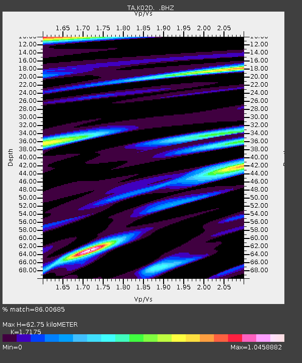
| Estimated Moho Depth: |
62.75 km |
| Estimated Crust Vp/Vs: |
1.72 |
| Assumed Crust Vp: |
6.522 km/s |
| Estimated Crust Vs: |
3.797 km/s |
| Estimated Crust Poisson's Ratio: |
0.24 |
|
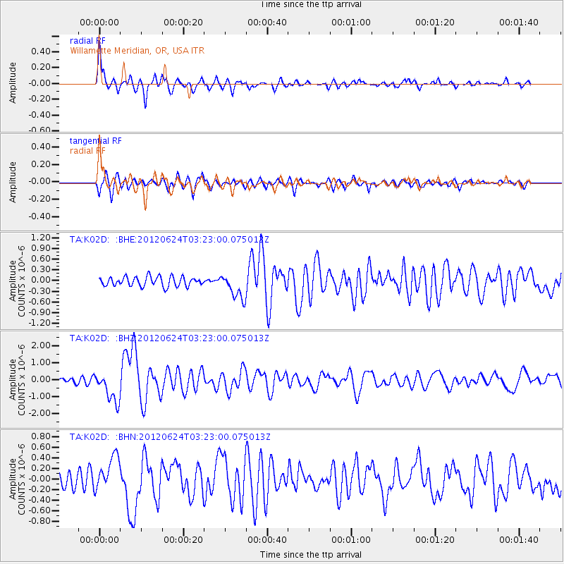
| Radial Match: |
86.00685 % |
| Radial Bump: |
400 |
| Transverse Match: |
69.527405 % |
| Transverse Bump: |
400 |
| SOD ConfigId: |
462790 |
| Insert Time: |
2013-02-12 17:40:35.214 +0000 |
| GWidth: |
2.5 |
| Max Bumps: |
400 |
| Tol: |
0.001 |
|
Signal To Noise
| Channel | StoN | STA | LTA |
| TA:K02D: :BHZ:20120624T03:23:00.075013Z | 7.92098 | 9.135607E-7 | 1.1533431E-7 |
| TA:K02D: :BHN:20120624T03:23:00.075013Z | 3.257984 | 3.288773E-7 | 1.0094503E-7 |
| TA:K02D: :BHE:20120624T03:23:00.075013Z | 2.7693574 | 3.5948827E-7 | 1.2980927E-7 |
| Arrivals |
| Ps | 7.4 SECOND |
| PpPs | 24 SECOND |
| PsPs/PpSs | 32 SECOND |


