You are here: Home > Network List > TA - USArray Transportable Network (new EarthScope stations) Stations List
> Station D03D Eldon, WA, USA > Earthquake Result Viewer
D03D Eldon, WA, USA - Earthquake Result Viewer
| Earthquake location: |
Near East Coast Of Kamchatka |
| Earthquake latitude/longitude: |
57.6/163.2 |
| Earthquake time(UTC): |
2012/06/24 (176) 03:15:01 GMT |
| Earthquake Depth: |
10 km |
| Earthquake Magnitude: |
5.8 MB, 5.8 MS, 6.0 MW, 6.1 MW |
| Earthquake Catalog/Contributor: |
WHDF/NEIC |
|
| Network: |
TA USArray Transportable Network (new EarthScope stations) |
| Station: |
D03D Eldon, WA, USA |
| Lat/Lon: |
47.53 N/123.09 W |
| Elevation: |
262 m |
|
| Distance: |
43.8 deg |
| Az: |
70.071 deg |
| Baz: |
311.673 deg |
| Ray Param: |
0.072331935 |
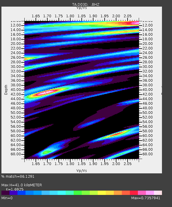
| Estimated Moho Depth: |
41.0 km |
| Estimated Crust Vp/Vs: |
1.69 |
| Assumed Crust Vp: |
6.566 km/s |
| Estimated Crust Vs: |
3.88 km/s |
| Estimated Crust Poisson's Ratio: |
0.23 |
|
| Radial Match: |
86.1291 % |
| Radial Bump: |
287 |
| Transverse Match: |
78.39413 % |
| Transverse Bump: |
382 |
| SOD ConfigId: |
462790 |
| Insert Time: |
2013-02-12 17:42:17.188 +0000 |
| GWidth: |
2.5 |
| Max Bumps: |
400 |
| Tol: |
0.001 |
|

Signal To Noise
| Channel | StoN | STA | LTA |
| TA:D03D: :BHZ:20120624T03:22:36.075013Z | 9.626937 | 9.249411E-7 | 9.6078445E-8 |
| TA:D03D: :BHN:20120624T03:22:36.075013Z | 5.2397213 | 3.1437148E-7 | 5.9997745E-8 |
| TA:D03D: :BHE:20120624T03:22:36.075013Z | 5.084772 | 3.1675322E-7 | 6.2294475E-8 |
| Arrivals |
| Ps | 4.6 SECOND |
| PpPs | 16 SECOND |
| PsPs/PpSs | 20 SECOND |


