You are here: Home > Network List > TA - USArray Transportable Network (new EarthScope stations) Stations List
> Station F34A Alexandria, MN, USA > Earthquake Result Viewer
F34A Alexandria, MN, USA - Earthquake Result Viewer
| Earthquake location: |
Near East Coast Of Kamchatka |
| Earthquake latitude/longitude: |
57.6/163.2 |
| Earthquake time(UTC): |
2012/06/24 (176) 03:15:01 GMT |
| Earthquake Depth: |
10 km |
| Earthquake Magnitude: |
5.8 MB, 5.8 MS, 6.0 MW, 6.1 MW |
| Earthquake Catalog/Contributor: |
WHDF/NEIC |
|
| Network: |
TA USArray Transportable Network (new EarthScope stations) |
| Station: |
F34A Alexandria, MN, USA |
| Lat/Lon: |
45.80 N/95.26 W |
| Elevation: |
419 m |
|
| Distance: |
58.2 deg |
| Az: |
53.745 deg |
| Baz: |
321.644 deg |
| Ray Param: |
0.062989354 |
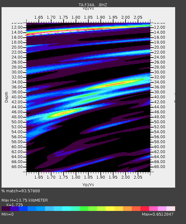
| Estimated Moho Depth: |
13.75 km |
| Estimated Crust Vp/Vs: |
1.73 |
| Assumed Crust Vp: |
6.571 km/s |
| Estimated Crust Vs: |
3.809 km/s |
| Estimated Crust Poisson's Ratio: |
0.25 |
|
| Radial Match: |
93.57688 % |
| Radial Bump: |
400 |
| Transverse Match: |
58.539062 % |
| Transverse Bump: |
400 |
| SOD ConfigId: |
462790 |
| Insert Time: |
2013-02-12 17:43:56.484 +0000 |
| GWidth: |
2.5 |
| Max Bumps: |
400 |
| Tol: |
0.001 |
|

Signal To Noise
| Channel | StoN | STA | LTA |
| TA:F34A: :BHZ:20120624T03:24:24.475007Z | 18.54153 | 1.0266415E-6 | 5.5369835E-8 |
| TA:F34A: :BHN:20120624T03:24:24.475007Z | 4.5964313 | 4.04997E-7 | 8.8111186E-8 |
| TA:F34A: :BHE:20120624T03:24:24.475007Z | 2.7685752 | 2.7199118E-7 | 9.824229E-8 |
| Arrivals |
| Ps | 1.6 SECOND |
| PpPs | 5.4 SECOND |
| PsPs/PpSs | 7.0 SECOND |


