You are here: Home > Network List > G - GEOSCOPE Stations List
> Station SSB Saint Sauveur Badole, France > Earthquake Result Viewer
SSB Saint Sauveur Badole, France - Earthquake Result Viewer

| Earthquake location: |
Near Coast Of Northern Calif. |
| Earthquake latitude/longitude: |
40.2/-124.3 |
| Earthquake time(UTC): |
1991/08/17 (229) 19:29:40 GMT |
| Earthquake Depth: |
12 km |
| Earthquake Magnitude: |
6.1 MB, 6.0 MS, 6.0 ML |
| Earthquake Catalog/Contributor: |
WHDF/NEIC |
|
| Network: |
G GEOSCOPE |
| Station: |
SSB Saint Sauveur Badole, France |
| Lat/Lon: |
45.28 N/4.54 E |
| Elevation: |
700 m |
|
| Distance: |
83.3 deg |
| Az: |
33.594 deg |
| Baz: |
323.135 deg |
| Ray Param: |
0.046267793 |
| Estimated Moho Depth: |
67.0 km |
| Estimated Crust Vp/Vs: |
2.10 |
| Assumed Crust Vp: |
6.1 km/s |
| Estimated Crust Vs: |
2.912 km/s |
| Estimated Crust Poisson's Ratio: |
0.35 |
|
| Radial Match: |
90.46894 % |
| Radial Bump: |
400 |
| Transverse Match: |
81.73031 % |
| Transverse Bump: |
400 |
| SOD ConfigId: |
16938 |
| Insert Time: |
2010-02-27 00:06:29.571 +0000 |
| GWidth: |
2.5 |
| Max Bumps: |
400 |
| Tol: |
0.001 |
|
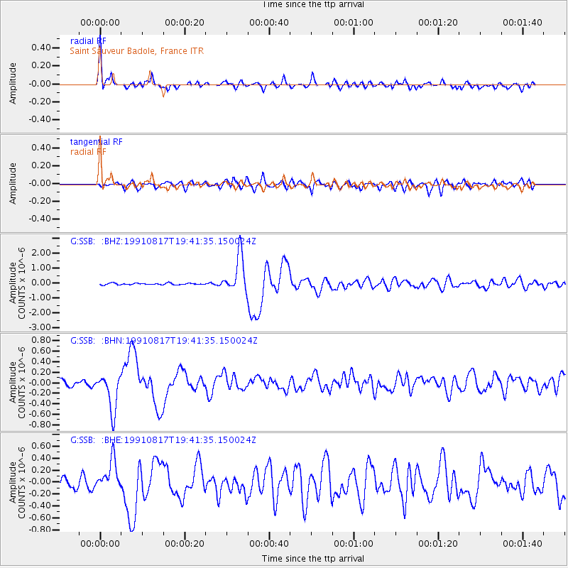
Signal To Noise
| Channel | StoN | STA | LTA |
| G:SSB: :BHN:19910817T19:41:35.150024Z | 7.8662686 | 3.6809254E-7 | 4.679379E-8 |
| G:SSB: :BHE:19910817T19:41:35.150024Z | 3.370554 | 2.6592124E-7 | 7.889541E-8 |
| G:SSB: :BHZ:19910817T19:41:35.150024Z | 23.997198 | 1.2995582E-6 | 5.415458E-8 |
| Arrivals |
| Ps | 12 SECOND |
| PpPs | 33 SECOND |
| PsPs/PpSs | 46 SECOND |


