You are here: Home > Network List > G - GEOSCOPE Stations List
> Station SSB Saint Sauveur Badole, France > Earthquake Result Viewer
SSB Saint Sauveur Badole, France - Earthquake Result Viewer
| Earthquake location: |
Kuril Islands |
| Earthquake latitude/longitude: |
45.6/151.7 |
| Earthquake time(UTC): |
1991/12/13 (347) 18:59:11 GMT |
| Earthquake Depth: |
52 km |
| Earthquake Magnitude: |
6.2 MB |
| Earthquake Catalog/Contributor: |
WHDF/NEIC |
|
| Network: |
G GEOSCOPE |
| Station: |
SSB Saint Sauveur Badole, France |
| Lat/Lon: |
45.28 N/4.54 E |
| Elevation: |
700 m |
|
| Distance: |
85.0 deg |
| Az: |
337.408 deg |
| Baz: |
22.477 deg |
| Ray Param: |
0.04498303 |
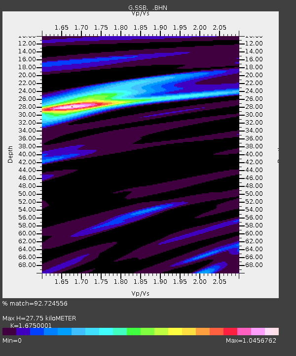
| Estimated Moho Depth: |
27.75 km |
| Estimated Crust Vp/Vs: |
1.68 |
| Assumed Crust Vp: |
6.1 km/s |
| Estimated Crust Vs: |
3.642 km/s |
| Estimated Crust Poisson's Ratio: |
0.22 |
|
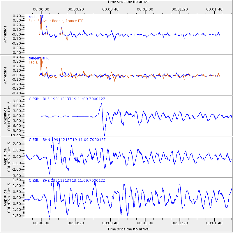
| Radial Match: |
92.724556 % |
| Radial Bump: |
288 |
| Transverse Match: |
74.32426 % |
| Transverse Bump: |
400 |
| SOD ConfigId: |
16938 |
| Insert Time: |
2010-02-27 00:06:34.773 +0000 |
| GWidth: |
2.5 |
| Max Bumps: |
400 |
| Tol: |
0.001 |
|
Signal To Noise
| Channel | StoN | STA | LTA |
| G:SSB: :BHN:19911213T19:11:09.700012Z | 4.465936 | 8.3725894E-7 | 1.8747669E-7 |
| G:SSB: :BHE:19911213T19:11:09.700012Z | 2.5215275 | 5.7470027E-7 | 2.279175E-7 |
| G:SSB: :BHZ:19911213T19:11:09.700012Z | 10.683627 | 2.980776E-6 | 2.790041E-7 |
| Arrivals |
| Ps | 3.1 SECOND |
| PpPs | 12 SECOND |
| PsPs/PpSs | 15 SECOND |


