You are here: Home > Network List > G - GEOSCOPE Stations List
> Station SSB Saint Sauveur Badole, France > Earthquake Result Viewer
SSB Saint Sauveur Badole, France - Earthquake Result Viewer
| Earthquake location: |
Kuril Islands |
| Earthquake latitude/longitude: |
48.7/154.9 |
| Earthquake time(UTC): |
1991/07/13 (194) 12:15:13 GMT |
| Earthquake Depth: |
40 km |
| Earthquake Magnitude: |
5.7 MB, 5.9 MS, 5.7 UNKNOWN |
| Earthquake Catalog/Contributor: |
WHDF/NEIC |
|
| Network: |
G GEOSCOPE |
| Station: |
SSB Saint Sauveur Badole, France |
| Lat/Lon: |
45.28 N/4.54 E |
| Elevation: |
700 m |
|
| Distance: |
82.9 deg |
| Az: |
339.425 deg |
| Baz: |
19.242 deg |
| Ray Param: |
0.04653126 |
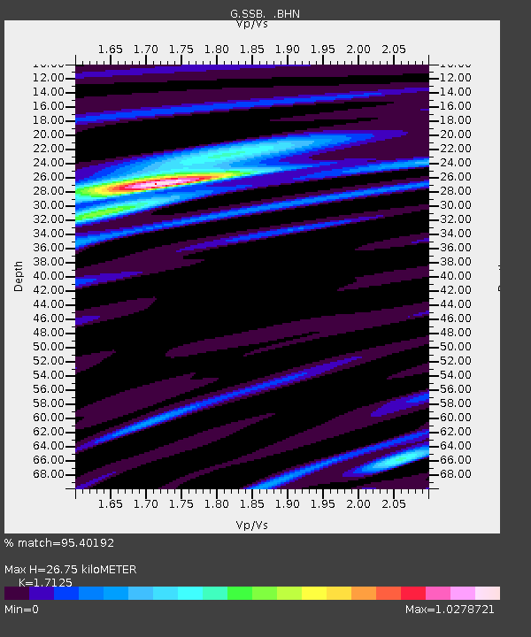
| Estimated Moho Depth: |
26.75 km |
| Estimated Crust Vp/Vs: |
1.71 |
| Assumed Crust Vp: |
6.1 km/s |
| Estimated Crust Vs: |
3.562 km/s |
| Estimated Crust Poisson's Ratio: |
0.24 |
|
| Radial Match: |
95.40192 % |
| Radial Bump: |
400 |
| Transverse Match: |
85.65793 % |
| Transverse Bump: |
400 |
| SOD ConfigId: |
17000 |
| Insert Time: |
2010-02-27 00:06:36.416 +0000 |
| GWidth: |
2.5 |
| Max Bumps: |
400 |
| Tol: |
0.001 |
|

Signal To Noise
| Channel | StoN | STA | LTA |
| G:SSB: :BHN:19910713T12:27:02.400012Z | 6.6884336 | 3.3955345E-7 | 5.0767262E-8 |
| G:SSB: :BHE:19910713T12:27:02.400012Z | 3.4254677 | 2.2063136E-7 | 6.440912E-8 |
| G:SSB: :BHZ:19910713T12:27:02.400012Z | 14.967826 | 9.726306E-7 | 6.4981414E-8 |
| Arrivals |
| Ps | 3.2 SECOND |
| PpPs | 12 SECOND |
| PsPs/PpSs | 15 SECOND |


