You are here: Home > Network List > TA - USArray Transportable Network (new EarthScope stations) Stations List
> Station J38A Wedel Dairy, Riceville, IA, USA > Earthquake Result Viewer
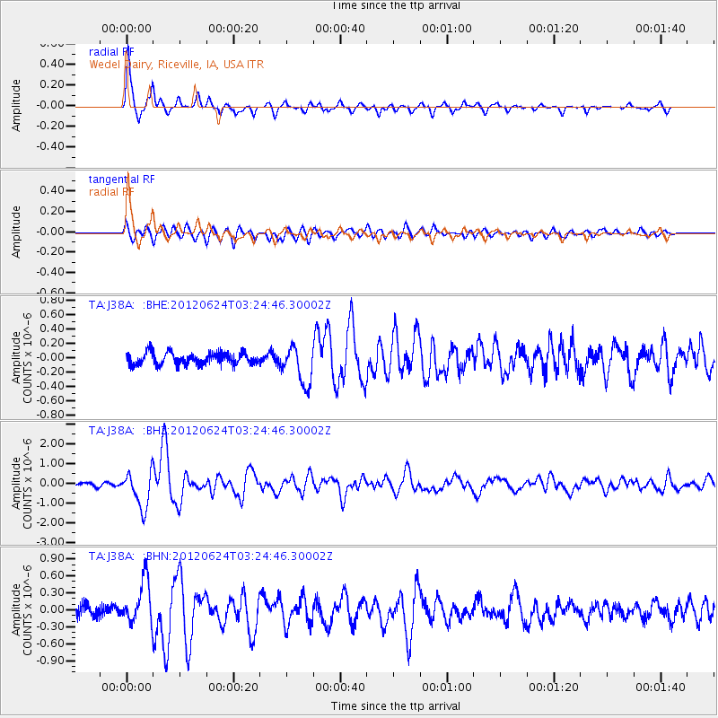
J38A Wedel Dairy, Riceville, IA, USA - Earthquake Result Viewer

| Earthquake location: |
Near East Coast Of Kamchatka |
| Earthquake latitude/longitude: |
57.6/163.2 |
| Earthquake time(UTC): |
2012/06/24 (176) 03:15:01 GMT |
| Earthquake Depth: |
10 km |
| Earthquake Magnitude: |
5.8 MB, 5.8 MS, 6.0 MW, 6.1 MW |
| Earthquake Catalog/Contributor: |
WHDF/NEIC |
|
| Network: |
TA USArray Transportable Network (new EarthScope stations) |
| Station: |
J38A Wedel Dairy, Riceville, IA, USA |
| Lat/Lon: |
43.32 N/92.48 W |
| Elevation: |
371 m |
|
| Distance: |
61.4 deg |
| Az: |
53.657 deg |
| Baz: |
323.546 deg |
| Ray Param: |
0.06090315 |
| Estimated Moho Depth: |
30.0 km |
| Estimated Crust Vp/Vs: |
2.03 |
| Assumed Crust Vp: |
6.53 km/s |
| Estimated Crust Vs: |
3.221 km/s |
| Estimated Crust Poisson's Ratio: |
0.34 |
|
| Radial Match: |
91.577065 % |
| Radial Bump: |
335 |
| Transverse Match: |
83.375694 % |
| Transverse Bump: |
400 |
| SOD ConfigId: |
462790 |
| Insert Time: |
2013-02-12 17:48:02.472 +0000 |
| GWidth: |
2.5 |
| Max Bumps: |
400 |
| Tol: |
0.001 |
|
Signal To Noise
| Channel | StoN | STA | LTA |
| TA:J38A: :BHZ:20120624T03:24:46.30002Z | 11.971393 | 9.1549134E-7 | 7.647325E-8 |
| TA:J38A: :BHN:20120624T03:24:46.30002Z | 4.049286 | 3.8894524E-7 | 9.60528E-8 |
| TA:J38A: :BHE:20120624T03:24:46.30002Z | 3.205626 | 2.646865E-7 | 8.256936E-8 |
| Arrivals |
| Ps | 4.9 SECOND |
| PpPs | 13 SECOND |
| PsPs/PpSs | 18 SECOND |


