You are here: Home > Network List > TA - USArray Transportable Network (new EarthScope stations) Stations List
> Station K37A Belmond, IA, USA > Earthquake Result Viewer
K37A Belmond, IA, USA - Earthquake Result Viewer

| Earthquake location: |
Near East Coast Of Kamchatka |
| Earthquake latitude/longitude: |
57.6/163.2 |
| Earthquake time(UTC): |
2012/06/24 (176) 03:15:01 GMT |
| Earthquake Depth: |
10 km |
| Earthquake Magnitude: |
5.8 MB, 5.8 MS, 6.0 MW, 6.1 MW |
| Earthquake Catalog/Contributor: |
WHDF/NEIC |
|
| Network: |
TA USArray Transportable Network (new EarthScope stations) |
| Station: |
K37A Belmond, IA, USA |
| Lat/Lon: |
42.77 N/93.64 W |
| Elevation: |
365 m |
|
| Distance: |
61.3 deg |
| Az: |
54.812 deg |
| Baz: |
323.309 deg |
| Ray Param: |
0.060945578 |
| Estimated Moho Depth: |
22.25 km |
| Estimated Crust Vp/Vs: |
1.60 |
| Assumed Crust Vp: |
6.53 km/s |
| Estimated Crust Vs: |
4.082 km/s |
| Estimated Crust Poisson's Ratio: |
0.18 |
|
| Radial Match: |
92.84494 % |
| Radial Bump: |
400 |
| Transverse Match: |
82.953186 % |
| Transverse Bump: |
400 |
| SOD ConfigId: |
462790 |
| Insert Time: |
2013-02-12 17:48:13.716 +0000 |
| GWidth: |
2.5 |
| Max Bumps: |
400 |
| Tol: |
0.001 |
|
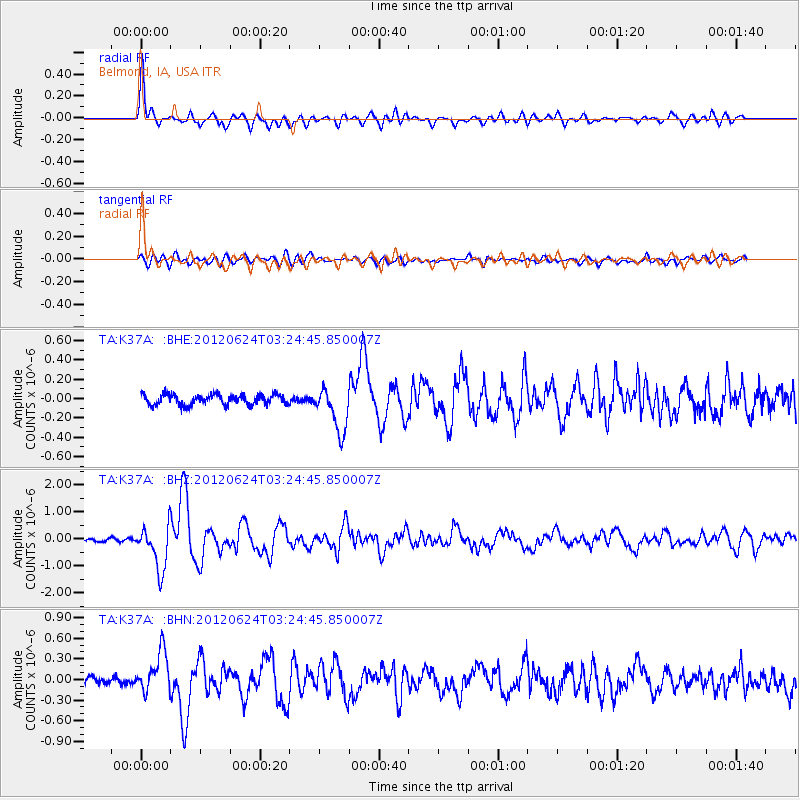
Signal To Noise
| Channel | StoN | STA | LTA |
| TA:K37A: :BHZ:20120624T03:24:45.850007Z | 18.076624 | 8.145965E-7 | 4.506353E-8 |
| TA:K37A: :BHN:20120624T03:24:45.850007Z | 4.9566708 | 2.9463666E-7 | 5.9442453E-8 |
| TA:K37A: :BHE:20120624T03:24:45.850007Z | 4.3613253 | 2.3161299E-7 | 5.31061E-8 |
| Arrivals |
| Ps | 2.2 SECOND |
| PpPs | 8.4 SECOND |
| PsPs/PpSs | 11 SECOND |


