You are here: Home > Network List > G - GEOSCOPE Stations List
> Station SSB Saint Sauveur Badole, France > Earthquake Result Viewer
SSB Saint Sauveur Badole, France - Earthquake Result Viewer
| Earthquake location: |
Off East Coast Of Kamchatka |
| Earthquake latitude/longitude: |
52.9/160.0 |
| Earthquake time(UTC): |
1992/03/02 (062) 12:29:40 GMT |
| Earthquake Depth: |
44 km |
| Earthquake Magnitude: |
6.5 MB, 6.8 MS, 6.7 UNKNOWN |
| Earthquake Catalog/Contributor: |
WHDF/NEIC |
|
| Network: |
G GEOSCOPE |
| Station: |
SSB Saint Sauveur Badole, France |
| Lat/Lon: |
45.28 N/4.54 E |
| Elevation: |
700 m |
|
| Distance: |
80.0 deg |
| Az: |
342.672 deg |
| Baz: |
14.812 deg |
| Ray Param: |
0.048522003 |
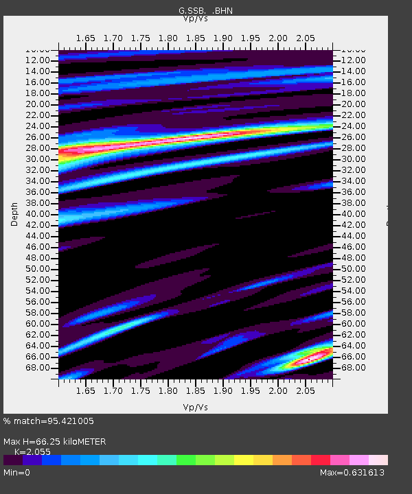
| Estimated Moho Depth: |
66.25 km |
| Estimated Crust Vp/Vs: |
2.06 |
| Assumed Crust Vp: |
6.1 km/s |
| Estimated Crust Vs: |
2.968 km/s |
| Estimated Crust Poisson's Ratio: |
0.34 |
|
| Radial Match: |
95.421005 % |
| Radial Bump: |
373 |
| Transverse Match: |
76.779945 % |
| Transverse Bump: |
400 |
| SOD ConfigId: |
16938 |
| Insert Time: |
2010-02-27 00:06:37.572 +0000 |
| GWidth: |
2.5 |
| Max Bumps: |
400 |
| Tol: |
0.001 |
|

Signal To Noise
| Channel | StoN | STA | LTA |
| G:SSB: :BHN:19920302T12:41:13.749011Z | 20.627981 | 4.8613833E-6 | 2.3566936E-7 |
| G:SSB: :BHE:19920302T12:41:13.749011Z | 6.2575116 | 1.7865124E-6 | 2.8549886E-7 |
| G:SSB: :BHZ:19920302T12:41:13.749011Z | 47.128376 | 1.30680155E-5 | 2.772855E-7 |
| Arrivals |
| Ps | 12 SECOND |
| PpPs | 32 SECOND |
| PsPs/PpSs | 44 SECOND |


