You are here: Home > Network List > TA - USArray Transportable Network (new EarthScope stations) Stations List
> Station F32A Veblen, SD, USA > Earthquake Result Viewer
F32A Veblen, SD, USA - Earthquake Result Viewer
| Earthquake location: |
Near East Coast Of Kamchatka |
| Earthquake latitude/longitude: |
57.6/163.2 |
| Earthquake time(UTC): |
2012/06/24 (176) 03:15:01 GMT |
| Earthquake Depth: |
10 km |
| Earthquake Magnitude: |
5.8 MB, 5.8 MS, 6.0 MW, 6.1 MW |
| Earthquake Catalog/Contributor: |
WHDF/NEIC |
|
| Network: |
TA USArray Transportable Network (new EarthScope stations) |
| Station: |
F32A Veblen, SD, USA |
| Lat/Lon: |
45.87 N/97.13 W |
| Elevation: |
371 m |
|
| Distance: |
57.3 deg |
| Az: |
54.894 deg |
| Baz: |
320.921 deg |
| Ray Param: |
0.06355309 |
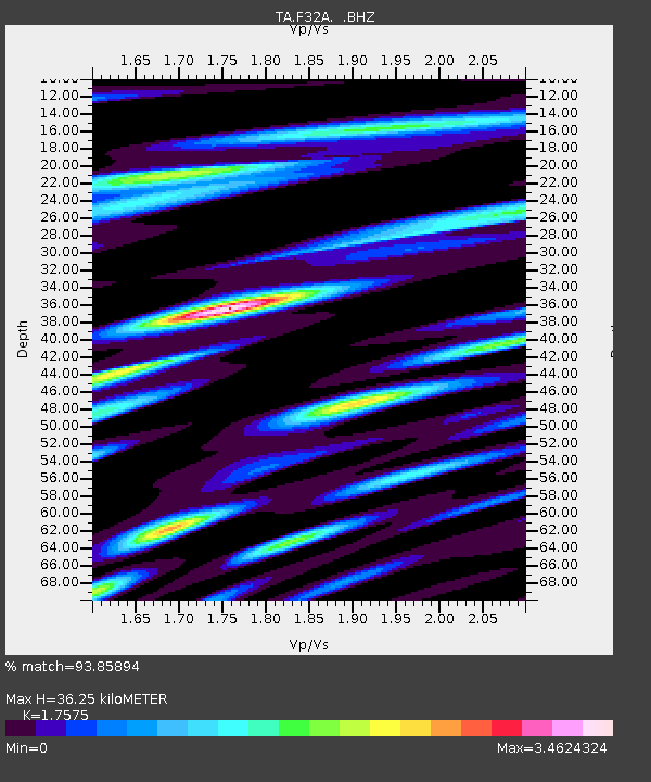
| Estimated Moho Depth: |
36.25 km |
| Estimated Crust Vp/Vs: |
1.76 |
| Assumed Crust Vp: |
6.552 km/s |
| Estimated Crust Vs: |
3.728 km/s |
| Estimated Crust Poisson's Ratio: |
0.26 |
|
| Radial Match: |
93.85894 % |
| Radial Bump: |
400 |
| Transverse Match: |
90.65957 % |
| Transverse Bump: |
400 |
| SOD ConfigId: |
462790 |
| Insert Time: |
2013-02-12 17:49:19.258 +0000 |
| GWidth: |
2.5 |
| Max Bumps: |
400 |
| Tol: |
0.001 |
|
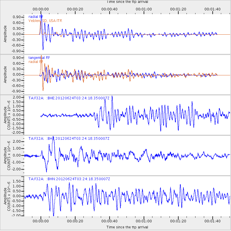
Signal To Noise
| Channel | StoN | STA | LTA |
| TA:F32A: :BHZ:20120624T03:24:18.350007Z | 11.665558 | 9.356514E-7 | 8.020631E-8 |
| TA:F32A: :BHN:20120624T03:24:18.350007Z | 7.092344 | 4.7357887E-7 | 6.6773254E-8 |
| TA:F32A: :BHE:20120624T03:24:18.350007Z | 7.0373397 | 5.3572825E-7 | 7.612653E-8 |
| Arrivals |
| Ps | 4.4 SECOND |
| PpPs | 14 SECOND |
| PsPs/PpSs | 19 SECOND |


