You are here: Home > Network List > G - GEOSCOPE Stations List
> Station SSB Saint Sauveur Badole, France > Earthquake Result Viewer
SSB Saint Sauveur Badole, France - Earthquake Result Viewer

| Earthquake location: |
Near Coast Of Northern Calif. |
| Earthquake latitude/longitude: |
40.4/-124.3 |
| Earthquake time(UTC): |
1992/04/25 (116) 18:06:04 GMT |
| Earthquake Depth: |
15 km |
| Earthquake Magnitude: |
6.4 MB, 7.1 MS |
| Earthquake Catalog/Contributor: |
WHDF/NEIC |
|
| Network: |
G GEOSCOPE |
| Station: |
SSB Saint Sauveur Badole, France |
| Lat/Lon: |
45.28 N/4.54 E |
| Elevation: |
700 m |
|
| Distance: |
83.2 deg |
| Az: |
33.621 deg |
| Baz: |
323.189 deg |
| Ray Param: |
0.046350777 |
| Estimated Moho Depth: |
28.25 km |
| Estimated Crust Vp/Vs: |
1.65 |
| Assumed Crust Vp: |
6.1 km/s |
| Estimated Crust Vs: |
3.703 km/s |
| Estimated Crust Poisson's Ratio: |
0.21 |
|
| Radial Match: |
97.061584 % |
| Radial Bump: |
387 |
| Transverse Match: |
82.87829 % |
| Transverse Bump: |
400 |
| SOD ConfigId: |
16938 |
| Insert Time: |
2010-02-27 00:06:41.579 +0000 |
| GWidth: |
2.5 |
| Max Bumps: |
400 |
| Tol: |
0.001 |
|
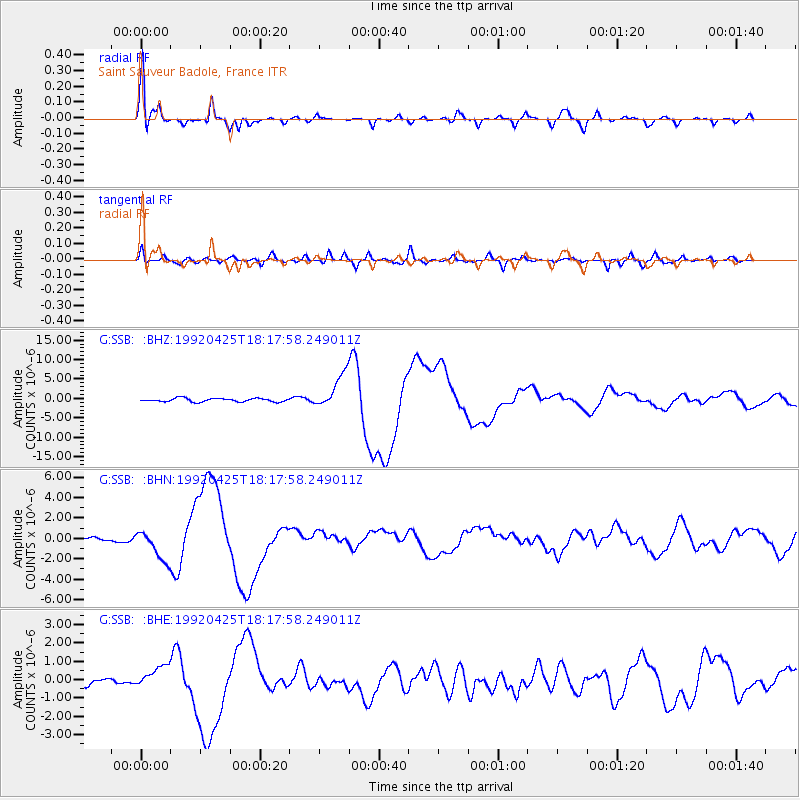
Signal To Noise
| Channel | StoN | STA | LTA |
| G:SSB: :BHN:19920425T18:17:58.249011Z | 8.447302 | 1.4860831E-6 | 1.75924E-7 |
| G:SSB: :BHE:19920425T18:17:58.249011Z | 1.9982083 | 6.126781E-7 | 3.066137E-7 |
| G:SSB: :BHZ:19920425T18:17:58.249011Z | 9.832275 | 4.4103513E-6 | 4.4855855E-7 |
| Arrivals |
| Ps | 3.1 SECOND |
| PpPs | 12 SECOND |
| PsPs/PpSs | 15 SECOND |


