You are here: Home > Network List > TA - USArray Transportable Network (new EarthScope stations) Stations List
> Station P37A Lathrop, MO, USA > Earthquake Result Viewer
P37A Lathrop, MO, USA - Earthquake Result Viewer
| Earthquake location: |
Near East Coast Of Kamchatka |
| Earthquake latitude/longitude: |
57.6/163.2 |
| Earthquake time(UTC): |
2012/06/24 (176) 03:15:01 GMT |
| Earthquake Depth: |
10 km |
| Earthquake Magnitude: |
5.8 MB, 5.8 MS, 6.0 MW, 6.1 MW |
| Earthquake Catalog/Contributor: |
WHDF/NEIC |
|
| Network: |
TA USArray Transportable Network (new EarthScope stations) |
| Station: |
P37A Lathrop, MO, USA |
| Lat/Lon: |
39.59 N/94.35 W |
| Elevation: |
300 m |
|
| Distance: |
63.6 deg |
| Az: |
57.421 deg |
| Baz: |
324.05 deg |
| Ray Param: |
0.059493404 |
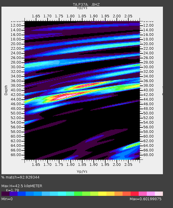
| Estimated Moho Depth: |
42.5 km |
| Estimated Crust Vp/Vs: |
1.78 |
| Assumed Crust Vp: |
6.498 km/s |
| Estimated Crust Vs: |
3.65 km/s |
| Estimated Crust Poisson's Ratio: |
0.27 |
|
| Radial Match: |
92.929344 % |
| Radial Bump: |
400 |
| Transverse Match: |
67.539795 % |
| Transverse Bump: |
400 |
| SOD ConfigId: |
462790 |
| Insert Time: |
2013-02-12 17:52:09.745 +0000 |
| GWidth: |
2.5 |
| Max Bumps: |
400 |
| Tol: |
0.001 |
|
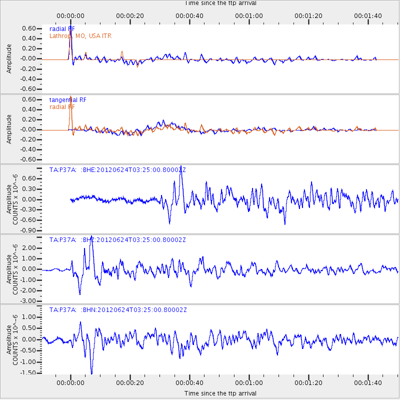
Signal To Noise
| Channel | StoN | STA | LTA |
| TA:P37A: :BHZ:20120624T03:25:00.80002Z | 18.926138 | 9.664102E-7 | 5.10622E-8 |
| TA:P37A: :BHN:20120624T03:25:00.80002Z | 5.021022 | 3.1398594E-7 | 6.253427E-8 |
| TA:P37A: :BHE:20120624T03:25:00.80002Z | 5.1761637 | 2.624534E-7 | 5.070423E-8 |
| Arrivals |
| Ps | 5.3 SECOND |
| PpPs | 17 SECOND |
| PsPs/PpSs | 23 SECOND |


