You are here: Home > Network List > TA - USArray Transportable Network (new EarthScope stations) Stations List
> Station P38A Dawn, MO, USA > Earthquake Result Viewer
P38A Dawn, MO, USA - Earthquake Result Viewer
| Earthquake location: |
Near East Coast Of Kamchatka |
| Earthquake latitude/longitude: |
57.6/163.2 |
| Earthquake time(UTC): |
2012/06/24 (176) 03:15:01 GMT |
| Earthquake Depth: |
10 km |
| Earthquake Magnitude: |
5.8 MB, 5.8 MS, 6.0 MW, 6.1 MW |
| Earthquake Catalog/Contributor: |
WHDF/NEIC |
|
| Network: |
TA USArray Transportable Network (new EarthScope stations) |
| Station: |
P38A Dawn, MO, USA |
| Lat/Lon: |
39.62 N/93.53 W |
| Elevation: |
248 m |
|
| Distance: |
63.9 deg |
| Az: |
56.826 deg |
| Baz: |
324.305 deg |
| Ray Param: |
0.059270088 |
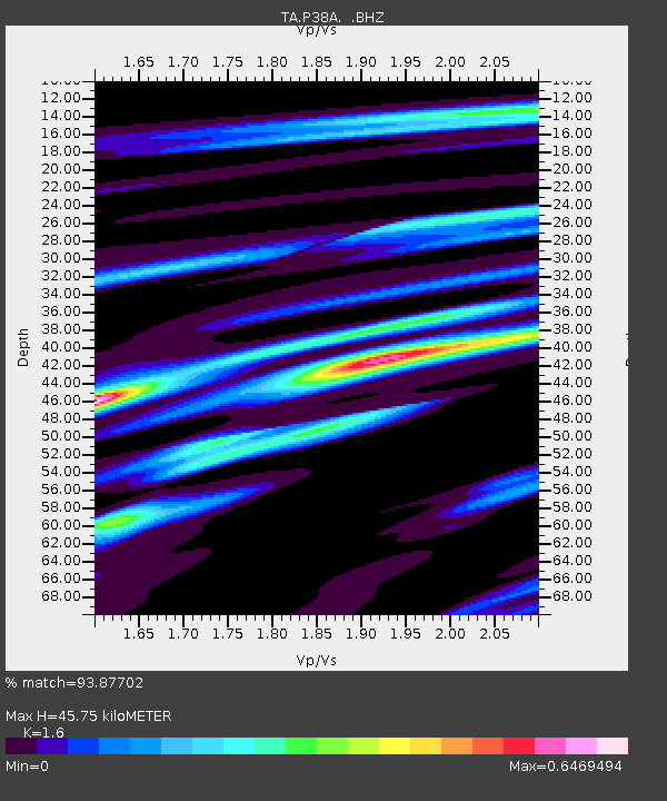
| Estimated Moho Depth: |
45.75 km |
| Estimated Crust Vp/Vs: |
1.60 |
| Assumed Crust Vp: |
6.498 km/s |
| Estimated Crust Vs: |
4.061 km/s |
| Estimated Crust Poisson's Ratio: |
0.18 |
|
| Radial Match: |
93.87702 % |
| Radial Bump: |
304 |
| Transverse Match: |
73.45976 % |
| Transverse Bump: |
355 |
| SOD ConfigId: |
462790 |
| Insert Time: |
2013-02-12 17:52:19.538 +0000 |
| GWidth: |
2.5 |
| Max Bumps: |
400 |
| Tol: |
0.001 |
|

Signal To Noise
| Channel | StoN | STA | LTA |
| TA:P38A: :BHZ:20120624T03:25:03.05002Z | 15.8309965 | 9.5100256E-7 | 6.007219E-8 |
| TA:P38A: :BHN:20120624T03:25:03.05002Z | 7.3061576 | 3.644429E-7 | 4.988161E-8 |
| TA:P38A: :BHE:20120624T03:25:03.05002Z | 3.9948676 | 2.3667819E-7 | 5.924557E-8 |
| Arrivals |
| Ps | 4.4 SECOND |
| PpPs | 17 SECOND |
| PsPs/PpSs | 22 SECOND |


