You are here: Home > Network List > G - GEOSCOPE Stations List
> Station SSB Saint Sauveur Badole, France > Earthquake Result Viewer
SSB Saint Sauveur Badole, France - Earthquake Result Viewer
| Earthquake location: |
Pakistan |
| Earthquake latitude/longitude: |
33.3/71.3 |
| Earthquake time(UTC): |
1992/05/20 (141) 12:20:35 GMT |
| Earthquake Depth: |
33 km |
| Earthquake Magnitude: |
6.0 MB, 6.0 MS |
| Earthquake Catalog/Contributor: |
WHDF/NEIC |
|
| Network: |
G GEOSCOPE |
| Station: |
SSB Saint Sauveur Badole, France |
| Lat/Lon: |
45.28 N/4.54 E |
| Elevation: |
700 m |
|
| Distance: |
51.6 deg |
| Az: |
304.177 deg |
| Baz: |
78.835 deg |
| Ray Param: |
0.06722724 |
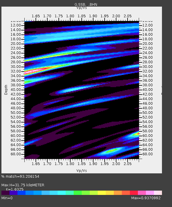
| Estimated Moho Depth: |
31.75 km |
| Estimated Crust Vp/Vs: |
1.63 |
| Assumed Crust Vp: |
6.1 km/s |
| Estimated Crust Vs: |
3.737 km/s |
| Estimated Crust Poisson's Ratio: |
0.20 |
|
| Radial Match: |
93.206154 % |
| Radial Bump: |
400 |
| Transverse Match: |
81.04913 % |
| Transverse Bump: |
400 |
| SOD ConfigId: |
16938 |
| Insert Time: |
2010-02-27 00:06:44.721 +0000 |
| GWidth: |
2.5 |
| Max Bumps: |
400 |
| Tol: |
0.001 |
|
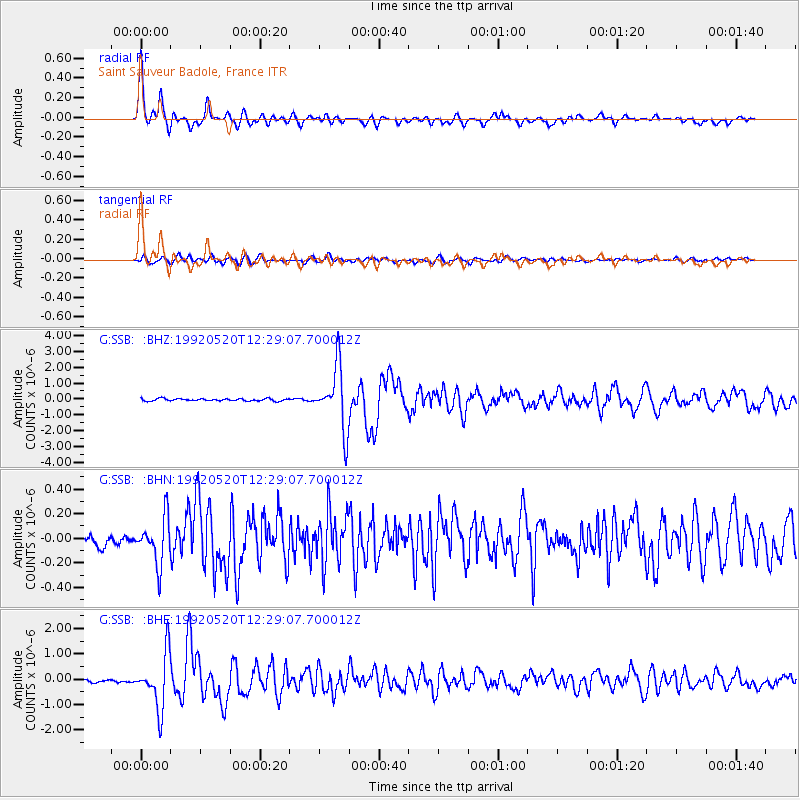
Signal To Noise
| Channel | StoN | STA | LTA |
| G:SSB: :BHN:19920520T12:29:07.700012Z | 3.4823709 | 1.8845398E-7 | 5.4116573E-8 |
| G:SSB: :BHE:19920520T12:29:07.700012Z | 17.693624 | 1.0712373E-6 | 6.054369E-8 |
| G:SSB: :BHZ:19920520T12:29:07.700012Z | 26.761461 | 1.9572303E-6 | 7.313615E-8 |
| Arrivals |
| Ps | 3.5 SECOND |
| PpPs | 13 SECOND |
| PsPs/PpSs | 16 SECOND |


