You are here: Home > Network List > TA - USArray Transportable Network (new EarthScope stations) Stations List
> Station R40A Maddie's Station, St. Elizabeth, MO, USA > Earthquake Result Viewer
R40A Maddie's Station, St. Elizabeth, MO, USA - Earthquake Result Viewer
| Earthquake location: |
Near East Coast Of Kamchatka |
| Earthquake latitude/longitude: |
57.6/163.2 |
| Earthquake time(UTC): |
2012/06/24 (176) 03:15:01 GMT |
| Earthquake Depth: |
10 km |
| Earthquake Magnitude: |
5.8 MB, 5.8 MS, 6.0 MW, 6.1 MW |
| Earthquake Catalog/Contributor: |
WHDF/NEIC |
|
| Network: |
TA USArray Transportable Network (new EarthScope stations) |
| Station: |
R40A Maddie's Station, St. Elizabeth, MO, USA |
| Lat/Lon: |
38.29 N/92.27 W |
| Elevation: |
213 m |
|
| Distance: |
65.6 deg |
| Az: |
56.788 deg |
| Baz: |
325.081 deg |
| Ray Param: |
0.0581896 |
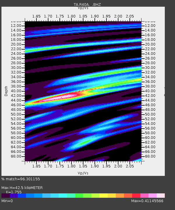
| Estimated Moho Depth: |
42.5 km |
| Estimated Crust Vp/Vs: |
1.75 |
| Assumed Crust Vp: |
6.498 km/s |
| Estimated Crust Vs: |
3.702 km/s |
| Estimated Crust Poisson's Ratio: |
0.26 |
|
| Radial Match: |
96.301155 % |
| Radial Bump: |
238 |
| Transverse Match: |
84.60394 % |
| Transverse Bump: |
400 |
| SOD ConfigId: |
462790 |
| Insert Time: |
2013-02-12 17:53:35.823 +0000 |
| GWidth: |
2.5 |
| Max Bumps: |
400 |
| Tol: |
0.001 |
|

Signal To Noise
| Channel | StoN | STA | LTA |
| TA:R40A: :BHZ:20120624T03:25:13.824983Z | 14.039158 | 1.0410051E-6 | 7.4150115E-8 |
| TA:R40A: :BHN:20120624T03:25:13.824983Z | 7.0228486 | 3.5250244E-7 | 5.0193655E-8 |
| TA:R40A: :BHE:20120624T03:25:13.824983Z | 5.6509385 | 2.2031237E-7 | 3.898686E-8 |
| Arrivals |
| Ps | 5.2 SECOND |
| PpPs | 17 SECOND |
| PsPs/PpSs | 22 SECOND |


