You are here: Home > Network List > TA - USArray Transportable Network (new EarthScope stations) Stations List
> Station T40A Mansfield, MO, USA > Earthquake Result Viewer
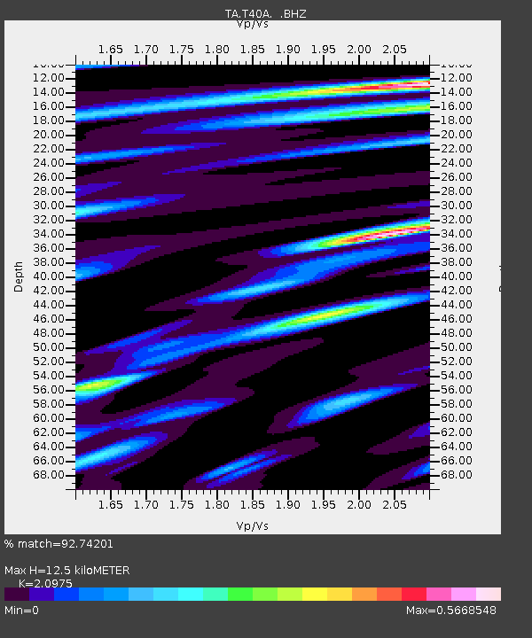
T40A Mansfield, MO, USA - Earthquake Result Viewer
| Earthquake location: |
Near East Coast Of Kamchatka |
| Earthquake latitude/longitude: |
57.6/163.2 |
| Earthquake time(UTC): |
2012/06/24 (176) 03:15:01 GMT |
| Earthquake Depth: |
10 km |
| Earthquake Magnitude: |
5.8 MB, 5.8 MS, 6.0 MW, 6.1 MW |
| Earthquake Catalog/Contributor: |
WHDF/NEIC |
|
| Network: |
TA USArray Transportable Network (new EarthScope stations) |
| Station: |
T40A Mansfield, MO, USA |
| Lat/Lon: |
37.15 N/92.52 W |
| Elevation: |
399 m |
|
| Distance: |
66.4 deg |
| Az: |
57.679 deg |
| Baz: |
325.29 deg |
| Ray Param: |
0.057651423 |
| Estimated Moho Depth: |
12.5 km |
| Estimated Crust Vp/Vs: |
2.10 |
| Assumed Crust Vp: |
6.53 km/s |
| Estimated Crust Vs: |
3.113 km/s |
| Estimated Crust Poisson's Ratio: |
0.35 |
|
| Radial Match: |
92.74201 % |
| Radial Bump: |
352 |
| Transverse Match: |
76.573326 % |
| Transverse Bump: |
400 |
| SOD ConfigId: |
462790 |
| Insert Time: |
2013-02-12 17:54:05.517 +0000 |
| GWidth: |
2.5 |
| Max Bumps: |
400 |
| Tol: |
0.001 |
|

Signal To Noise
| Channel | StoN | STA | LTA |
| TA:T40A: :BHZ:20120624T03:25:19.100007Z | 13.98725 | 7.3538547E-7 | 5.2575412E-8 |
| TA:T40A: :BHN:20120624T03:25:19.100007Z | 6.1830225 | 2.726685E-7 | 4.4099547E-8 |
| TA:T40A: :BHE:20120624T03:25:19.100007Z | 3.7385378 | 2.06683E-7 | 5.528445E-8 |
| Arrivals |
| Ps | 2.2 SECOND |
| PpPs | 5.7 SECOND |
| PsPs/PpSs | 7.9 SECOND |


