You are here: Home > Network List > TA - USArray Transportable Network (new EarthScope stations) Stations List
> Station V39A Pettigrew, AR, USA > Earthquake Result Viewer
V39A Pettigrew, AR, USA - Earthquake Result Viewer
| Earthquake location: |
Near East Coast Of Kamchatka |
| Earthquake latitude/longitude: |
57.6/163.2 |
| Earthquake time(UTC): |
2012/06/24 (176) 03:15:01 GMT |
| Earthquake Depth: |
10 km |
| Earthquake Magnitude: |
5.8 MB, 5.8 MS, 6.0 MW, 6.1 MW |
| Earthquake Catalog/Contributor: |
WHDF/NEIC |
|
| Network: |
TA USArray Transportable Network (new EarthScope stations) |
| Station: |
V39A Pettigrew, AR, USA |
| Lat/Lon: |
35.84 N/93.64 W |
| Elevation: |
744 m |
|
| Distance: |
66.9 deg |
| Az: |
59.303 deg |
| Baz: |
325.267 deg |
| Ray Param: |
0.0572801 |
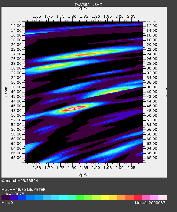
| Estimated Moho Depth: |
46.75 km |
| Estimated Crust Vp/Vs: |
1.81 |
| Assumed Crust Vp: |
6.498 km/s |
| Estimated Crust Vs: |
3.595 km/s |
| Estimated Crust Poisson's Ratio: |
0.28 |
|
| Radial Match: |
95.78524 % |
| Radial Bump: |
400 |
| Transverse Match: |
78.49277 % |
| Transverse Bump: |
400 |
| SOD ConfigId: |
462790 |
| Insert Time: |
2013-02-12 17:55:45.422 +0000 |
| GWidth: |
2.5 |
| Max Bumps: |
400 |
| Tol: |
0.001 |
|

Signal To Noise
| Channel | StoN | STA | LTA |
| TA:V39A: :BHZ:20120624T03:25:22.649995Z | 11.662227 | 9.520067E-7 | 8.163164E-8 |
| TA:V39A: :BHN:20120624T03:25:22.649995Z | 12.235893 | 4.1644E-7 | 3.4034297E-8 |
| TA:V39A: :BHE:20120624T03:25:22.649995Z | 4.9632444 | 2.178992E-7 | 4.3902574E-8 |
| Arrivals |
| Ps | 6.0 SECOND |
| PpPs | 19 SECOND |
| PsPs/PpSs | 25 SECOND |


