You are here: Home > Network List > TA - USArray Transportable Network (new EarthScope stations) Stations List
> Station 140A Cam and Jess, Hughton, LA, USA > Earthquake Result Viewer
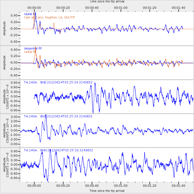
140A Cam and Jess, Hughton, LA, USA - Earthquake Result Viewer

| Earthquake location: |
Near East Coast Of Kamchatka |
| Earthquake latitude/longitude: |
57.6/163.2 |
| Earthquake time(UTC): |
2012/06/24 (176) 03:15:01 GMT |
| Earthquake Depth: |
10 km |
| Earthquake Magnitude: |
5.8 MB, 5.8 MS, 6.0 MW, 6.1 MW |
| Earthquake Catalog/Contributor: |
WHDF/NEIC |
|
| Network: |
TA USArray Transportable Network (new EarthScope stations) |
| Station: |
140A Cam and Jess, Hughton, LA, USA |
| Lat/Lon: |
32.64 N/93.57 W |
| Elevation: |
56 m |
|
| Distance: |
69.6 deg |
| Az: |
61.189 deg |
| Baz: |
326.005 deg |
| Ray Param: |
0.055532973 |
| Estimated Moho Depth: |
10.0 km |
| Estimated Crust Vp/Vs: |
1.60 |
| Assumed Crust Vp: |
6.245 km/s |
| Estimated Crust Vs: |
3.903 km/s |
| Estimated Crust Poisson's Ratio: |
0.18 |
|
| Radial Match: |
87.71908 % |
| Radial Bump: |
400 |
| Transverse Match: |
80.46643 % |
| Transverse Bump: |
400 |
| SOD ConfigId: |
462790 |
| Insert Time: |
2013-02-12 17:56:43.053 +0000 |
| GWidth: |
2.5 |
| Max Bumps: |
400 |
| Tol: |
0.001 |
|
Signal To Noise
| Channel | StoN | STA | LTA |
| TA:140A: :BHZ:20120624T03:25:39.324983Z | 9.462934 | 1.0353788E-6 | 1.0941414E-7 |
| TA:140A: :BHN:20120624T03:25:39.324983Z | 1.5197641 | 2.386316E-7 | 1.5701885E-7 |
| TA:140A: :BHE:20120624T03:25:39.324983Z | 0.8800834 | 1.4447632E-7 | 1.6416207E-7 |
| Arrivals |
| Ps | 1.0 SECOND |
| PpPs | 4.0 SECOND |
| PsPs/PpSs | 5.0 SECOND |


