You are here: Home > Network List > TA - USArray Transportable Network (new EarthScope stations) Stations List
> Station 146A Union, MS, USA > Earthquake Result Viewer
146A Union, MS, USA - Earthquake Result Viewer
| Earthquake location: |
Near East Coast Of Kamchatka |
| Earthquake latitude/longitude: |
57.6/163.2 |
| Earthquake time(UTC): |
2012/06/24 (176) 03:15:01 GMT |
| Earthquake Depth: |
10 km |
| Earthquake Magnitude: |
5.8 MB, 5.8 MS, 6.0 MW, 6.1 MW |
| Earthquake Catalog/Contributor: |
WHDF/NEIC |
|
| Network: |
TA USArray Transportable Network (new EarthScope stations) |
| Station: |
146A Union, MS, USA |
| Lat/Lon: |
32.64 N/89.06 W |
| Elevation: |
164 m |
|
| Distance: |
71.7 deg |
| Az: |
57.817 deg |
| Baz: |
327.313 deg |
| Ray Param: |
0.05414731 |
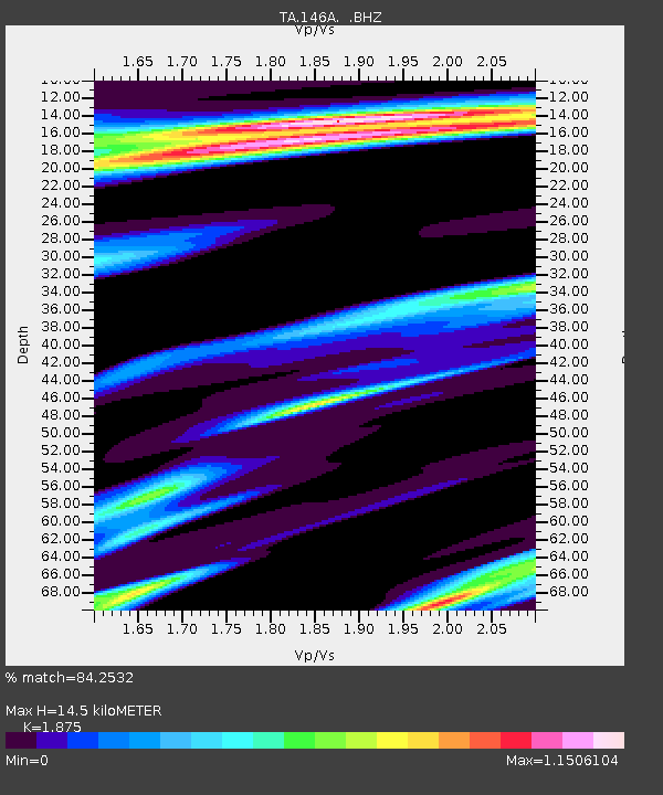
| Estimated Moho Depth: |
14.5 km |
| Estimated Crust Vp/Vs: |
1.88 |
| Assumed Crust Vp: |
6.201 km/s |
| Estimated Crust Vs: |
3.307 km/s |
| Estimated Crust Poisson's Ratio: |
0.30 |
|
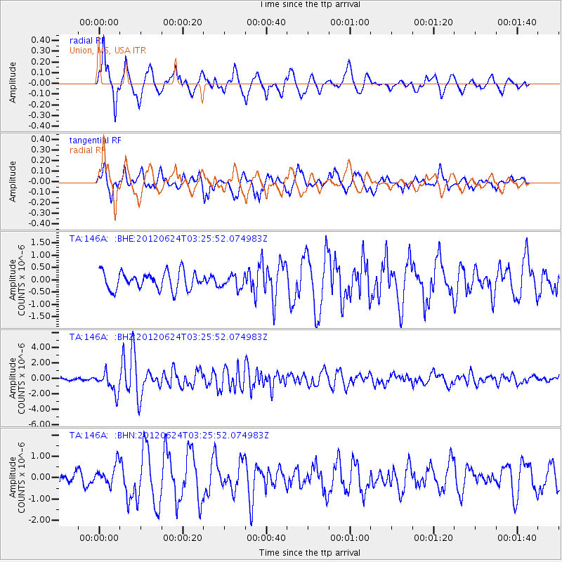
| Radial Match: |
84.2532 % |
| Radial Bump: |
400 |
| Transverse Match: |
79.673485 % |
| Transverse Bump: |
400 |
| SOD ConfigId: |
462790 |
| Insert Time: |
2013-02-12 17:59:57.507 +0000 |
| GWidth: |
2.5 |
| Max Bumps: |
400 |
| Tol: |
0.001 |
|
Signal To Noise
| Channel | StoN | STA | LTA |
| TA:146A: :BHZ:20120624T03:25:52.074983Z | 7.5609202 | 1.3619872E-6 | 1.801351E-7 |
| TA:146A: :BHN:20120624T03:25:52.074983Z | 1.6103525 | 5.0025284E-7 | 3.1064803E-7 |
| TA:146A: :BHE:20120624T03:25:52.074983Z | 0.74286145 | 2.6688997E-7 | 3.5927286E-7 |
| Arrivals |
| Ps | 2.1 SECOND |
| PpPs | 6.5 SECOND |
| PsPs/PpSs | 8.6 SECOND |


