You are here: Home > Network List > TA - USArray Transportable Network (new EarthScope stations) Stations List
> Station Y47A UCPARC, Winfield, AL, USA > Earthquake Result Viewer
Y47A UCPARC, Winfield, AL, USA - Earthquake Result Viewer
| Earthquake location: |
Near East Coast Of Kamchatka |
| Earthquake latitude/longitude: |
57.6/163.2 |
| Earthquake time(UTC): |
2012/06/24 (176) 03:15:01 GMT |
| Earthquake Depth: |
10 km |
| Earthquake Magnitude: |
5.8 MB, 5.8 MS, 6.0 MW, 6.1 MW |
| Earthquake Catalog/Contributor: |
WHDF/NEIC |
|
| Network: |
TA USArray Transportable Network (new EarthScope stations) |
| Station: |
Y47A UCPARC, Winfield, AL, USA |
| Lat/Lon: |
33.90 N/87.85 W |
| Elevation: |
160 m |
|
| Distance: |
71.2 deg |
| Az: |
56.2 deg |
| Baz: |
327.459 deg |
| Ray Param: |
0.054487 |
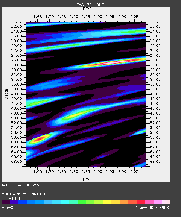
| Estimated Moho Depth: |
26.75 km |
| Estimated Crust Vp/Vs: |
1.96 |
| Assumed Crust Vp: |
6.565 km/s |
| Estimated Crust Vs: |
3.349 km/s |
| Estimated Crust Poisson's Ratio: |
0.32 |
|
| Radial Match: |
90.49656 % |
| Radial Bump: |
367 |
| Transverse Match: |
79.30866 % |
| Transverse Bump: |
400 |
| SOD ConfigId: |
462790 |
| Insert Time: |
2013-02-12 18:01:21.144 +0000 |
| GWidth: |
2.5 |
| Max Bumps: |
400 |
| Tol: |
0.001 |
|
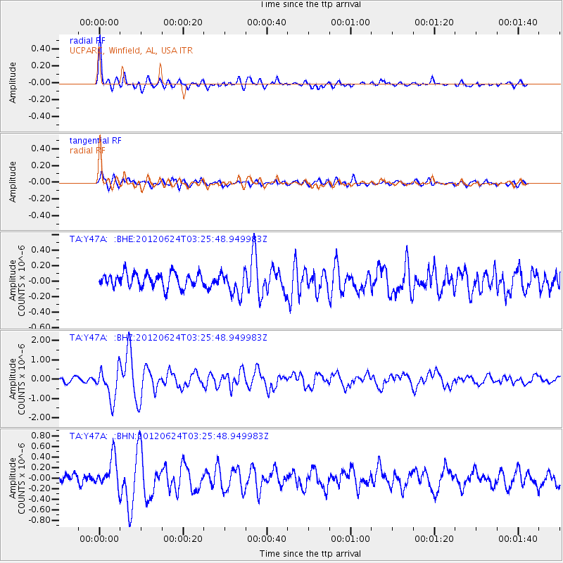
Signal To Noise
| Channel | StoN | STA | LTA |
| TA:Y47A: :BHZ:20120624T03:25:48.949983Z | 7.120921 | 8.2177957E-7 | 1.15403544E-7 |
| TA:Y47A: :BHN:20120624T03:25:48.949983Z | 3.7930808 | 2.9213274E-7 | 7.701727E-8 |
| TA:Y47A: :BHE:20120624T03:25:48.949983Z | 1.7760456 | 1.5880234E-7 | 8.941343E-8 |
| Arrivals |
| Ps | 4.0 SECOND |
| PpPs | 12 SECOND |
| PsPs/PpSs | 16 SECOND |


